|
||

|

|
|

|
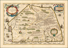
"The Great Game." Peterman's Map of the Roof of the World.
Detailed color-printed map covering the northwestern Himalaya Mountains, with Yarkand (in present-day China) in the upper right, and Peschawar (present-day Pakistan) in the lower left.
The Forsyth expedition to Central Asia was one of the most important, at least politically speaking, to have been carried out up to that point. It provided considerable information about the region borders of China, Russia, and British India. The key details the numerous explorations of the area throughout the 1860s and 1870s.
Forsyth's embassy to Yarkand took place several years before the Second Anglo-Afghan War (1878) and some twenty years before the Pamir Boundary Commission protocols brought "The Great Game" to an end by establishing the Russo-Afghan border.
The Great Game is a term used to describe the confrontation between the British and Russian Empires over territory in Central Asia. The region was seen as an integral buffer zone by both Britain and Russia; for the British, Russian control of Central Asia posed a risk of invasion to British India; whereas the Russians were eager to combat the expansion of the British Empire from India up to the southern border of the Russian Empire.
Although largely forgotten by history today, the Pamir Plateau was the focal point of one of the great geopolitical showdowns of the late 19th century.
August Heinrich Petermann (1822-1878) is a renowned German cartographer of the nineteenth century. Petermann studied cartography at the Geographical Art-School in Potsdam before traveling to Edinburgh to work with Dr. A. Keith Johnston on an English edition of Berghaus’ Physical Atlas. Two years later he moved to London, where he made maps and advised exploratory expeditions as they set off to explore the interior of Africa and the Arctic.
In 1854, Petermann returned to Germany to be Director of the Geographical Institute of Justus Perthes in Gotha. There, he was the editor of the Geographische Mittheilungen and Stieler’s Handatlas. The Royal Geographical Society of London awarded him their Gold Medal in 1860. He continued his interest in exploration in Germany, fundraising for the German Exploring Expeditions of 1868 and 1869-70, which sought an open Arctic sea. Tragically, he committed suicide in 1878.

![[Puducherry-- Hand Drawn Map] Plan de la Ville de Pondichery. Legende des Rues de la ville blanche et de la ville noire de Pondichery avec les numeros d'ordre correspondant a ceux du plan que Mr. le Gouvernor a approuve le Mai 1856](https://storage.googleapis.com/raremaps/img/small/58607.jpg)