|
||

|

|
|

|
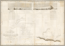
James Cook Ends the French North Pacific Geographic Myths of the Mid-Eighteenth Century
Rare map of the Northwest Coast of America and the Northeast Coast of Asia, showing Cook's track in search of the Northwest Passage.
This map is an updated version of the map which originally appeared in Philippe Buache's rare work, Considerations géographiques et physiques sur les nouvelles découvertes au nord de la grande mer, appellée vulgairement la Mer du Sud, published in Paris 1753-54, one of the scarcest works on the discoveries along the Northwest Coast of America in the mid-eighteenth century and part of a grand intellectual debate about the geography of the North Pacific.
The map in the Considerations géographiques et physiques was an extension of another map presented to the Académie des Sciences by Buache and Joseph-Nicolas De L’Isle in 1750 and published in 1752. This map revived Guillaume De L’Isle’s Sea of the West and integrated the controversial account of Admiral de la Fonte, who suggested there were a series of lakes that stretched across the continent, in effect providing an inland Northwest Passage.
Buache and De L’Isle’s map, and Buache’s subsequent maps, led to an international discussion about the quality and interpretation of cartographic sources, as well as fed the already raging debate about the possibility of a Northwest Passage. The discussion about Fonte and the geography of the North Pacific continued for several decades and this is a late entry on the subject.
By the time this map was published, James Cook had entered the fray; his third expedition was focused on settling the question of a Northwest Passage. His exhaustive search ruled out an easy open-ocean passage and obvious inland waterway passages but, as this map suggests, not every geographer was willing to drop the idea entirely. As the text to the left of the map, which overviews Cook’s third voyage, explains, “With regard to Passage to the North-West, although it has not been discovered after so much research, it is probable that it exists.”
In addition to its rarity, this version of the Buache’s map is noteworthy for its systematic reporting of many of the lingering myths of the interior of Western North America. Dezauche has included Cook’s third voyage track and redrawn the outline of Alaska to reflect his findings and those of the Russian Academy of Sciences, who had been incensed at the first Buache De L’Isle map (De L’Isle had previously worked for the Academy and they thought he had absconded with their materials). However, he has also retained the lakes described by Fonte as well as the possibility of an inland sea.
The map retains a Lac de Fuentes, which would seem to be a last-ditch effort to preserve the myth of the Sea of the West in the wake of Cook's exploration of the northwestern coastline. The large, open sea is gone, but in its place is the R. de los Reyes which leads to the lake, which in turn nearly reaches the Chesterfield Inlet and Hudson’s Bay. To the south of the lake is an ambiguous extension that connects to the R. de l’Ouest, where the original entrance to the Sea of the West was on the 1752 map. Additionally, there is another lake, Lac de Velasco, in Alaska, suggesting a direct water course to the Glacial Sea above North America.
Along the coast of what is now British Columbia is a note, “Fousang des Chinois.” This note stems from the work of French Orientalist Le Guignes, who hypothesized that the Chinese arrived in the New World over a millennium before the Europeans in his 1761 work, Recherches sur les Navigations des Chinois du Cote de l'Amerique, et sur quelques Peuples situés a l'extremite orientale de l"asie. Le Guignes was named a fellow of the Royal Society of London in 1752 and his work was well known across Enlightenment Europe and integrated into the maps of Buache.
Another mythic tie is the toponym Quivira across much of the West. Quivira was supposedly one of the Seven Cities of Gold sought by the Spanish explorer Francisco Vasquez de Coronado in 1541. In 1539, Coronado wandered over what today is Arizona and New Mexico, eventually heading to what is now Kansas to find the supposedly rich city of Quivira. Although he never found the cities or the gold, the name stuck on maps of southwest North America, wandering from east to west.
The Baron Lahontan and his travels, real and imagined
A round lake in the American West is labelled “Mozeemleck.” These are part of the geography described by the Baron Lahontan, a popular but ultimately specious source for western North America.
Louis-Armand de Lom d’Arce, the third Baron Lahontan, was a member of the aristocracy. Born in 1666, he was forced into a career in the military by the family’s hardship after his father’s death. He served across the Atlantic, in New France.
Lahontan was dispatched as part of a force who were to defeat the Iroquois tribes near the Great Lakes. In addition to, or perhaps instead of, his military duties he explored much of the upper Mississippi River Valley. While serving at Boucherville, Lahontan learned Algonquin. Later, he commanded Fort St. Joseph, on the site of what is now Detroit.
While Lahontan certainly saw a great deal of the Great Lakes region, in 1688 he set out on his most fantastic journey. So fantastic, in fact, that it is unclear whether or not it really happened. These travels included what he called the Rivière Longue, which some scholars believe was actually the Missouri River. He also reported a giant salt lake, around which the Tuhuglauk nation lived. However, Lahontan kept this strategically important detail secret while he served as Lieutenant-Governor in Placentia, Newfoundland and as he fled that position when faced with possible imprisonment.
In exile, Lahontan settled in the Netherlands in the mid-1690s, where he began to work on accounts of his travels. The first of these was Nouveaux Voyages dans l'Amerique Septentrionale (1703), which became a bestseller. It was printed in thirteen editions in fourteen years. This book included a description and map of the “Long River,” which was accepted and incorporated into the popular cartographic conception of the region by most of the leading mapmakers of the time, including Guillaume de L'Isle, Herman Moll, Henry Popple, and John Senex. The Tuhuglauk’s salt lake, in turn, would be combined with the geographic hypothesis of a Sea of the West.
Lahontan followed his 1703 memoir with two more, Memoires de l’Amerique Septentrionale, and Supplement aux Voyages ou Dialogues avec le sauvage Adario. Nouveaux Voyages dans l’Amerique Septentrionale. By the time he died, sometime before 1716, he was one of the most popular travel writers in Europe, despite the fact that many of his details were exaggerated or fictitious.
Martin Aguilar, Juan de la Fuca, and Admiral de la Fonte
The Pacific Northwest shown here is defined by the discoveries of three men, Martin Aguilar, Juan de la Fuca, and Admiral De Fonte, all of which were to prove dubious at best. The former navigator was a Spanish captain who sailed with Sebastian Vizcaino on a reconnaissance expedition up the California coast in 1602-3. Aguilar, commanding the Tres Reyes, was blown off course, to the north. When the seas calmed, Aguilar reported that he had found the mouth of a large river. Eighteenth-century geographers, including De L'Isle and Bauche, conjectured that the river was the entrance to the Sea of the West, even if the size of that sea varied over time.
Here, the River of the West is combined with the Entrée de Fuca. The authors are referring to Juan de la Fuca, the Castilianized name of Greek navigator Ioánnis Fokás (Phokás). Little archival evidence survives of Fuca's career, but a chance meeting with an English financier, Michael Lok, in Venice in 1596 gave birth to rumors of Fuca's voyages in the Pacific. Fuca reported that he had been sent north from New Spain twice in 1592 in search of the Strait of Anian. The Spanish Crown failed to reward Fuca's discovery of an opening in the coast at roughly 47° N latitude and Fuca left the Spanish service embittered. His story lived on in Lok's letters and eventually was published in Samuel Purchas' travel collection of 1625. On many eighteenth-century maps, including this one, Fuca's Strait is linked with a River or Sea of the West. In 1787, the present-day Juan de Fuca Strait was named by the wife of naval explorer Charles William Barkley, making permanent a label that had previously just been hopeful conjecture.
Even farther north are the aforementioned entrances leading to the lakes of Fuentes and Velasco, which relate to Admiral de Fonte. Admiral de Fonte supposedly sailed to the area in the mid-seventeenth century. The first mention of Fonte appears in two letters published in London in 1708 in two issues of The Monthly Miscellany or Memoirs for the Curious. The Fonte letters had been reprinted by Arthur Dobbs in his 1744 An Account of the Countries adjoining Hudson's Bay and were mentioned in other travel accounts . De L'Isle's copy of the letters came from Lord Forbes, British ambassador to Russia, as he explained in a memoir, Nouvelles Cartes des Decouvertes de l'Amiral de Fonte (Paris, 1753). He also read of them in Henry Ellis' account of the 1746-7 expedition to Wager Inlet.
The letters recounted that Fonte had found an inlet near 53°N which led to a series of lakes. While sailing northeast, Fonte eventually met with a Boston merchant ship, commanded by a Captain Shapley. One of Fonte's captains, separated from the Admiral, reported he had found no strait between the Pacific and the Davis Straits, yet had reached 79°N, helped by local indigenous peoples. This story, with its suggestion of water passages connecting the Pacific Northwest with the east, inspired hope in some and doubt in others in the mid-eighteenth century. A few, like Irish mapmaker John Green, thought the entire story a farce. Many, including De L'Isle and Buache, thought the information conformed neatly to other recent discoveries and included Fonte on their map.
In the June 1752 De L’Isle and Buache map, Fonte's entrance is at roughly 63°N latitude. In the face of criticism, De L'Isle published another map in September 1752 moving the entrance to 53°N, as the letters had stated. This caused a rift between De L'Isle and Buache, as the latter stuck to the initial misreading of the letters, as seen on this map published by Dezauche. Both men, however, continued to believe Fonte a credible source and continued to include him on their maps in some capacity.
All three men's discoveries, real or exaggerated, reshaped the Pacific Northwest for the next thirty years, until the discoveries by James Cook of the area between Alaska and Puget Sound. This is a landmark map in the history of cartography and perhaps the single most influential map of the region in the middle of the eighteenth century.
Cook's third voyage (1776-1780)
After two Pacific cruises that observed the Transit of Venus, charted New Zealand, the eastern coast of Australia, and many islands; and disproved the existence of a vast southern continent, Cook’s third voyage focused on searching for the Northwest Passage. It was also tasked with the return of Mai, a Ra’iatean man and the first Polynesian visitor to Britain, who had joined Cook’s second voyage.
Cook in the Resolution was joined by Charles Clerke in the Discovery. Resolution sailed in July from Plymouth, rounded the Cape of Good Hope, visited the Kerguelen group in the Southern Indian Ocean, then called at Tasmania before heading to New Zealand.
In the spring of 1777, the ships sailed north, first to Tonga, and then to Tahiti. They left Mai on Huahine in a wooden house built for him by the crew. Cook continued north and became the first European to encounter the Hawaiian Islands, in January 1778.
During the warm months (in the northern hemisphere) of 1778, Cook and his crew charted the northwestern coast of North America, calling at Nootka Sound and Prince William Sound. They went up the Cook Inlet, which they thought could be a Northwest Passage, but it proved to be a false start. Heading west, they skirted the Aleutians and sighted the Asian coast. In January 1779, they returned to Hawai’i to resupply and rest.
In Kealakekua Bay, Cook was greeted warmly by the Hawaiians. They stayed for three weeks, enjoying the considerable hospitality of the people. In early February, the ships set out for another northern tour, but only a few days from Hawai’i the Resolution’s mast was damaged, forcing their return.
This time, they were not welcomed by crowds. During a dispute over a stolen boat, a scuffle broke out. When it was over, sixteen Hawaiians, four marines, and Cook were dead.
Clerke took command. He forced the Hawaiians to give him Cook’s remains, which were buried at sea. He then led the ships north, passing through the Bering Strait before turning back due to ice. In August of 1779, Clerke too died, of consumption, while near Kamchatka. A third commander, John Gore, then had to lead the ships home.
The ships sighted Japan on their southward journey before calling at Macao. There, they made sizeable profits by selling sea otter pelts, kickstarting a new industry. By April 1780, the Resolution and Discovery were back at the Cape of Good Hope. They returned to Britain via the Orkneys, anchoring in the Thames on October 7, 1780.
Philippe Buache (1700-1773) was one of the most famous French geographers of the eighteenth century. Buache was married to the daughter of the eminent Guillaume Delisle and worked with his father-in-law, carrying on the business after Guillaume died. Buache gained the title geographe du roi in 1729 and was elected to the Academie des Sciences in the same year. Buache was a pioneering theoretical geographer, especially as regards contour lines and watersheds. He is best known for his works such as Considérations géographiques et physiques sur les découvertes nouvelles dans la grande mer (Paris, 1754).
Jean-Claude Dezauche (fl. 1780-1838) was a French map publisher. Initially, his work focused on engraving music, but he later turned primarily to cartography. His is best known for editing and reissuing the maps of Guilluame De L’Isle and Philippe Buache, two of the most skilled mapmakers of the eighteenth century. He acquired the plates of these two men’s work in 1780 from Buache’s heir, Jean-Nicolas Buache. Dezauche's business received a further boon when he received a privilege to sell the charts of the Dépôt de la Marine. His business was carried on by his son, Jean-Andre Dezauche.

![Index Map of the Civil Code of California Designed and Executed By Curtis Lindley . . . [bound into] Revised Laws of the State of California; In Four Codes: Political, Civil, Civil Procedure and Penal . . .](https://storage.googleapis.com/raremaps/img/small/84298.jpg)