This item has been sold, but you can enter your email address to be notified if another example becomes available.


|
||

|

|
|

|
Stock# 49624
Description
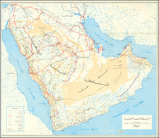
First edition of this Iraq War Evasion Chart, published by the Defense Mapping Agency of the US Government.
The map covers an area on the north side of the Persian Gulf, including Kuwait and parts of Iran and Iraq. The map also includes a survival guide, identifying edible and poisonous plants.
As noted on the map:
This Chart Is Intended For Survival Situations. Refer To Current Editions of Appropriate Aeronautical Charts For Flight Planning Operations.

![[ Cyprus, Syria, Palestine, etc. ]](https://storage.googleapis.com/raremaps/img/small/103027.jpg)