


|
||

|

|
|

|
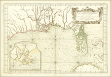
Rare map centered on the Gulf of Mexico, illustrating the important region in conflict among the French, Spanish, and English during the American Revolution
While the main battlefields of the American Revolution were in Britain's North American colonies, other European countries became involved in the conflict primarily to gain control of strategically important islands and lands in the Caribbean and the Gulf. The British had several lucrative island colonies including Jamaica, Barbados, and the Bahamas. Other islands, like Dominica, Tobago, and Granada, had recently been captured from the French in the French and Indian War and were still hotly contested. In addition, France wanted to defend at all costs St. Domingue, the sugar island that was more lucrative than all the British Caribbean holdings combined. Meanwhile, Spain still dreamed of reclaiming Jamaica and Florida.
To underline the importance of the Caribbean as compared to the American colonies, it is instructive to remember that immediately after the French recognized the colonies as independent in 1778, British Prime Minister Lord North ordered Sir Henry Clinton, commander of British forces in the colonies, to reinforce St. Lucia and defend the Caribbean colonies. He was told to do so at the expense of Philadelphia and New York, if necessary.
In 1780, when this map was published, the French had just sent a squadron in support of the American Army fighting in the thirteen colonies. It arrived early in July in Rhode Island. Farther south, the Americans surrendered Charleston, South Carolina to the British after being bottled in and bombarded. The city is marked on the map as Charles-Town. By September, the British had invaded North Carolina, occupying all the land shown north of Charleston on this map. However, on October 7, the Americans successfully rebuked British attempts to overrun the southern colonies at the Battle of King's Mountain in North Carolina.
In the Caribbean, the French re-occupied or captured British holdings including Dominica (1778), Saint Vincent (1779), Grenada (1779), and Tobago (1781). They also blockaded Jamaica and Barbados, leading to the death of thousands of slaves. In return, the British seized St. Lucia (1778). On the continent, Spanish forces harassed British forts in the Mississippi Valley, successfully seized all of West Florida, and fought off a British attempt on Nicaragua. This map shows this other theater of the American Revolution, reminding us that the war was fought on a global scale and involved not only Britain, but Spain and France as well. Furthermore, Louis Denis, the mapmaker, notes the indigenous groups resident throughout the territories, which makes visible an often-overlooked set of actors in this multi-faceted conflict.
What Denis could not have known when he made the map was that Spain had entered into secret negotiations with the British in March 1780. They wanted peace on the terms of uti posseditus, or possession as it stood at that time. The map also leaves out the Dutch, who were crucial as smugglers to the Americas. Britain, angry at this smuggling, declared war on the Dutch in 1780. All of these events make this map a remarkable snapshot of the American Revolution; it serves to reorient our understanding of the war and to highlight the international nature of the resentments and connections involved.
The importance of some islands is underlined by their inclusion as large insets. These include Dominique (Dominica), St. Vincent, Grenadine (Grenada), and Jamaica. The insets occupy the upper right corner of the map, in the open waters of the Atlantic. Florida is shown as an archipelago, with a fantastic river traversing from northeast to southwest. Forts are located throughout the Gulf region and the southern colonies.
The title cartouche is in the bottom left corner, placed over the Pacific Ocean off of Central America. The title is framed by lions guarding a family coat of arms on one side and an indigenous American seated on a bale of cotton and textiles on the other. The entire scene is set on a background of fertile land with trees and a waterfall, highlighting the productivity of the region for European colonizers. Denis, the mapmaker, underlines simultaneously the economic importance of the region alongside unease as to fluctuating boundaries and contradictory claims.
Louis Denis (1725-1794) was a French geographer and cartographer best known for his incomplete road atlas of France, Le Conducteur français. Originally trained as an engraver, he partnered with Louis-Charles Desnos to create and edit maps. Later, Denis served as geography tutor to the children of the French royal family. His pupils included the Duc de Berry, the future Louis XVI.
Denis was an important cartographer of the American Revolution. For example, his Carte du theâtre de la guerre présente en Amérique, was published, also by Paul André Bassett, in 1782. The present map was published in at least two editions, with this edition in 1780 and another in 1792. His publisher, Basset, was also quite active in the revolutionary period, before retiring in 1819.
Basset dedicated this map to a Mr. Le Noir, councilor of state and Lieutenant General of Police in Paris. This is Jean Charles Pierre Lenoir, head of the Paris police prior to the French Revolution. He went into exile in 1792 but eventually returned to France and died in 1807.
The map is quite rare. We note a copy referenced in Mapoteca Columbiana, as well as institutional copies in the American Geographical Society Collection (Wisconsin), the Library of Congress, the Jacksonville Public Library, the Clements Library (Michigan), Harvard University, the University of Bern, and the Bibliotheque Nationale.
http://www.militaryhistoryonline.com/revolutionarywar/articles/caribbean.aspx
O'Shaughnessy, Andrew Jackson. An Empire Divided: The American Revolution and the British Caribbean. Philadelphia: University of Pennsylvania Press, 2000.
Louis Denis (1725-1794) was a French geographer and cartographer best known for his incomplete road atlas of France, Le Conducteur français. Originally trained as an engraver, he partnered with Louis-Charles Desnos to create and edit maps. Later, Denis served as geography tutor to the children of the French royal family. His pupils included the Duc de Berry, the future Louis XVI.
![(Texas) Denkschrift über eine Reise nach Nord-Mexiko, verbunden mit der Expedition des Obersten Donniphan, in den Jahren 1846 und 1847. Von Dr. A. Wislizenus. Aus dem Englischen übertragen von George M. von Ross. Mit einem wiffenschaftlichen Anhange und drei Karten. [Description of a voyage to northern Mexico connected with Colonel Doniphan's expedition in 1846 and 1847 By Dr. A. Wislizenus. Translated from the English by George M. von Ross. With a scholarly appendix and three maps.]](https://storage.googleapis.com/raremaps/img/small/88574.jpg)
![[Pensacola] Plan de la Baye De Pansacola . . . 1744](https://storage.googleapis.com/raremaps/img/small/87767.jpg)
![[Shows Republic of Texas] United States and Texas](https://storage.googleapis.com/raremaps/img/small/101139.jpg)
