


|
||

|

|
|

|
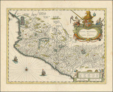
Early Photographic Copy of Important Manuscript Map of Zacatecas
The map is a reduced copy of an original, made by Lieutenant Juan Antonio de Evia for Intendante Don Francesco Rendon in 1797. This map originally appeared in Juan Antonio de Evia's book, entitled Noticias de Zacatecas de la Historia del Padre Andrés de Rivas, published in 1797 .
The map's title is deceptive, for in addition to Zacatecas, the area drawn also includes land in the intendencias of Guadalajara, San Luis Potosi, Durango, and the "Political and Military Government of the Frontier of San Luis Colotlan Subjugated to the Viceroy." The latter was originally under the control of New Galicia, but the indigenous uprisings against Spanish rule were so fierce and constant that the area was placed under military rule from the mid-eighteenth century until 1806.
The map is east-oriented and shows nine political units which surround the city of Zacatecas. The city itself is roughly in the center of the map, in the smallest political unit. In addition to this city, the only settlement of that classification shown, there are also villages, towns, congregations, and haciendas.
At the top right is a large, decorative cartouche showing the seal of Zacatecas: four conquistadors hold a medallion (with PLS II on it for Philip II of Spain) and are standing before a hill with an image of Nuestra Señora del Patrocinio de Zacatecas, with symbols of the sun and the moon on either side. The inscription reads, " Labor vincit omnia," or "work conquers all." The cartouche, ringed with flowers, holds the title.
Below it is a text box explaining the political jurisdictions and underlining how close and jumbled they are to each other. For example, the easternmost area is the subdelegación de Sierra de Pinos, which was under the control of Zacatecas. The bordering two partidos were under the control of Guadalajara, even though they were geographically closer to Zacatecas than Sierra de Pinos. In the top left corner is the scale, while the key is in the lower left corner. Each of the text portions are decorated with a floral design.
This map was made just as the Bourbon Reforms took hold. Within Spain, the reforms focused on the modernization of agriculture, ship construction, and infrastructure. However, the results were mixed. In Spanish America, reforms focused primarily on New Spain and took effect in the second half of the eighteenth-century.
Administratively, the viceroyalties and captaincies general were split and re-organized, an effort made to decentralize administration and increase revenue collection. This was legislated through the Real Ordenanza de Intendentes de Ejército y Provincia de Nueva-España, issued December 4, 1786. The ordenanza formed twelve intendencias in New Spain, which could be further subdivided into subdelegaciones and partidos, both of which are represented on this map.
The intendante of Zacatecas mentioned in the title of this map is Don Francisco Rendon. He ordered the map be made, most likely to clarify the newly-confusing geography caused by the intendencias. He served as intendente from 1796 to 1810, making the commissioning of this map one of his first acts in office. Prior to this assignment, Rendon served as representative to the American colonies during the Revolutionary War (where he corresponded with George Washington), in Louisiana as a government official, and in Veracruz.
The one who carried out the commission was former army lieutenant Jose Antonio de Evia. In the map's title he identifies himself as an infantry veteran and as a politician, the subdelegado in charge of the villages of Fresnillo and Xeréz, and the Tlaltenango Valley. All of these areas are depicted on the map, so Evia was drawing a region he knew well and was invested in.
In 1872, Frederik Muller, literary agent to the Smithsonian, offered a hand-drawn version of the map in a sales catalog for a sale in Amsterdam (p. 151). Two copies of an 1806 version of the map are referenced in Catalogue of the Maps, Charts, and Plans…in the British Museum (1861, p. 501). In Catalogue of Additions to the Manuscripts in the British Museum in the Years MDCCCLXXXVIII and MDCCCXCIII (1894), the 1797 edition is mentioned as now in the collections (p. 258). It is available in the collections of the British Library now: Map G in Add MS 34240.
Transcription of texts on map:
Title:
Plano topográfico de la Provincia de Zacatecas Reyno de N.E. Sacado y Delineado de orden de el S. D. Fran. Rendon. Yntendente de Egercito y de la misma Provincia Por Juan Antonio de Evia. Teniente Veterano de Infantaria, Justicia mayor y Subdelegado de las Villas de Fresnillo, Xeréz, y Valle de Tlaltenango: Ano de 1797.
Text in lower right corner:
Que el Partido de Aguascalientes y el de su agregado Tuchipila aunque pertenecen a la Yntendencia de Guad/a se han comprehendido en este Plano para que se conozca visiblemente que su Demarcación se introduce hasta una una [sic.] Legua de distancia de la Capital de Zacatecas.
El Real y Minas de Ojo-caliente y las haciendas de S. Diego y Buenavista, aunque corresponden a la Yntendencia de S. Luis Potosi, se han demarcado en este Plano para que se vea que dicha Yntendencia corta corta [sic.] con sus limites la de Zacatecas en el transito de ella para la Subdelegación de Sierra de Pinos.
Lo propio se albierte en quanto al Partido de Tlaltenango, que lo divide de dicha Yntendencia el Gobierno de las Froneras[sic.] de S. Luis de Colotlan.
Note in explanation:
Que para quese conozcan las Poblaciones que son Reales de Minas, antecede una R. al nombre de la ciudad, villa, or lugar que le son y se trabajan sus Minas actualmente.
Copies of the British Museum catalogs and the catalog of Frederik Muller are available on Google Books.
![[ The Silver Route -- Mexico City to Santa Fe, New Mexico ] Carte de la Route qui mene depuis la Capitale de la Nouvelle Espagne jusqu'a S. Fe. du Nouveau Mexique Dressee sur les Journaux de Don Pedro de Rivera et en partie sur les Observations Astronomique de Mr. de Humboldt.](https://storage.googleapis.com/raremaps/img/small/102164.jpg)