


|
||

|

|
|

|
Münster's well-known map of central and western Europe
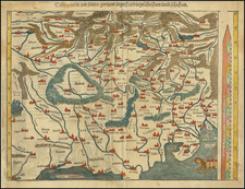
Early map of Poland, the Baltic, and the German Empire, extending to the Mare Germanicum, the English Channel, the Upper Rhine, Croatia, Poland, and Danzig, on the Baltic. The map appeared in the 1572 edition of Cosmographia universalis. It shows north-central and western Europe at a time when their trade was booming.
South is oriented at the top of the map. Towns are marked with towers and buildings, with forests and maps represented as well. Indeed, Bohemia is entirely ringed by forest. The map includes a large scale of German miles that also serves as a compass; it lines the right-hand side of the map. In the lower right corner, to the northwest, is a ship of Nordic seamen. They are sailing out of the border, reminding the viewer of Viking raids of centuries before.
Sebastian Münster (1489-1552) was a professor of Hebrew who taught at Heidelberg and Basel. He settled in the latter in 1529 and died there, of plague, in 1552. Münster made himself the center of a large network of scholars from whom he obtained geographic descriptions, maps, and directions. He is best known for his Cosmographia universalis, first published in 1554 and released in forty editions by 1628.
Sebastian Münster (1488-1552) was a cosmographer and professor of Hebrew who taught at Tübingen, Heidelberg, and Basel. He settled in the latter in 1529 and died there, of plague, in 1552. Münster made himself the center of a large network of scholars from whom he obtained geographic descriptions, maps, and directions.
As a young man, Münster joined the Franciscan order, in which he became a priest. He then studied geography at Tübingen, graduating in 1518. He moved to Basel, where he published a Hebrew grammar, one of the first books in Hebrew published in Germany. In 1521 Münster moved again, to Heidelberg, where he continued to publish Hebrew texts and the first German-produced books in Aramaic. After converting to Protestantism in 1529, he took over the chair of Hebrew at Basel, where he published his main Hebrew work, a two-volume Old Testament with a Latin translation.
Münster published his first known map, a map of Germany, in 1525. Three years later, he released a treatise on sundials. In 1540, he published Geographia universalis vetus et nova, an updated edition of Ptolemy’s Geographia. In addition to the Ptolemaic maps, Münster added 21 modern maps. One of Münster’s innovations was to include one map for each continent, a concept that would influence Ortelius and other early atlas makers. The Geographia was reprinted in 1542, 1545, and 1552.
He is best known for his Cosmographia universalis, first published in 1544 and released in at least 35 editions by 1628. It was the first German-language description of the world and contained 471 woodcuts and 26 maps over six volumes. Many of the maps were taken from the Geographia and modified over time. The Cosmographia was widely used in the sixteenth and seventeenth centuries. The text, woodcuts, and maps all influenced geographical thought for generations.
![[ Southwestern Prussia ] Des Konigreichs Preussen westsudlicher Theil mit der freyen Stadt Thorn Nro. 53.](https://storage.googleapis.com/raremaps/img/small/101864.jpg)
![[Gdansk]. Prospect, Grundris und Gegend der Polnischen velen Reichs und Handels=Stat Dantzig . . .](https://storage.googleapis.com/raremaps/img/small/35677.jpg)
![[Kingdom of Hungary] Royaume de Hongrie Divisee Dans Ces Cercles et Comtes . . . 1784](https://storage.googleapis.com/raremaps/img/small/47705.jpg)