


|
||

|

|
|

|
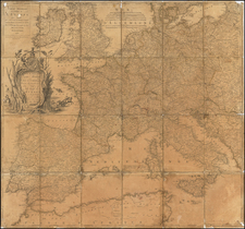
Very Rare First State of Hogenberg's Map of the Holy Roman Empire
This is an extremely rare, separately published map of the Holy Roman Empire by Frans Hogenberg in Cologne.
The densely-detailed map shows northern Europe from the eastern tip of England to Poland, and extends from the North Sea to Venice and the coast of Croatia. Towns are marked with small red buildings, with larger cities meriting a larger symbol. Political borders are marked with dotted lines and hills are also shown.
In the lower left is a grand cartouche fashioned to look like a monument. The steps at the bottom cleverly serve as the scale. The oval title cartouche is flanked by two winged mermaids holding a spear (left) and a frond (right). At the top, two small cherubs hold a sign that says, "Deutschlanndt,", which contrasts from the Latin title below it, "Germianiae Typus." The inclusion of both a scholarly and a vernacular name would likely increase the audience for the map.
In the upper right hand corner is the seal of the Holy Roman Empire: a double-headed reichsadler, or imperial eagle, topped with an elaborate crown. The double-headed reischadler was used by the Hapsburgs when in possession of the Empire in the early modern period. In the late medieval period the seal had a single reichsadler.
A final decorative element is in the lower right corner, a seal atop a text box proclaiming a dedication to Constantino von Lyskirchen, a German noble whose family was prominent in Cologne in the medieval and early modern periods. Several family members served as mayors of the city and the family was related to Prince Albert, Queen Victoria's husband.
The two states of Germaniae typus
Hogenberg's map of the Holy Roman Empire is one of the earliest obtainable printed maps to focus on this region. His plate would later be acquired by Johann Baptiste Vrients in 1603 and incorporated into later editions of Ortelius' Theatrum Orbis Terrarum.
The easiest way to distinguish between the original Hogenberg map and the later re-issue by Vrients is the addition by Vrients of a river below the word "Galliae" and above the left cherub above the cartouche, which is not present in the Hogenberg map. A second difference which can be easily seen is the larger lettering for "Sinus Hadriatic Pars" and the name "Rovigno" west of Venice on the Hogenberg map. On the later Vrients edition, the letters are re-engraved and smaller, with "Rovigno" omitted.
Frans Hogenberg and sixteenth-century Europe
Frans Hogenberg (ca. 1540-ca. 1590) was a Flemish and German engraver and mapmaker who also painted. He was born in Mechelen, south of Antwerp, the son of wood engraver and etcher Nicolas Hogenberg. Together with his father, brother (Remigius), uncle, and cousins, Frans was one member of a prominent artistic family in the Netherlands.
During the 1550s, Frans worked in Antwerp with the famous mapmaker Abraham Ortelius. There, he engraved the maps for Ortelius' groundbreaking first atlas, published in Antwerp in 1570, along with Johannes van Deotecum and Ambrosius and Ferdinand Arsenius. It is suspected he engraved the title page as well. Later, Ortelius supported Hogenberg with information for a different project, the Civitates orbis terrarium (edited by Georg Braun, engraved by Hogenberg, published in six volumes, Cologne, 1572-1617). Hogenberg engraved the majority of the work's 546 prospects and views.
It is possible that Frans spent some time in England while fleeing from religious persecution, but he was living and working in Cologne by 1580. That is the city where he died around 1590. In addition to his maps, he is known for his historical allegories and portraits. His brother, Remigius, also went on to some fame as an engraver, and he died around the same time as his brother.
Both Remigius and Frans were members of the Northern Renaissance. They might more accurately be referred to as inheritors of the values of Renaissance humanists, or men interested in cultivating an active, engaged civic life focused on (Classical) learning and virtue. This worldview was reflected in Ortelius' project to contain all the world in an atlas, or Hogenberg's desire to picture and describe all the great cities of Europe, so that others could learn of them and appreciate their similarities and differences.
The brothers Hogenberg lived in the Holy Roman Empire at a crucial moment. In 1519, Charles I became Charles V, King of Spain as well as Holy Roman Emperor. This was not the first time a Hapsburg had been elected Emperor-they continuously occupied the throne from 1438 to 1740-but it was the first time they had also held the throne of Spain.
During the sixteenth century, the Hapsburgs were in almost constant warfare with the Tudors, the French, and/or the Ottomans (not to mention internal conflicts). Simultaneously, the sixteenth century witnessed the Wars of Religion, terrible fighting between Catholics and Protestants that split the Holy Roman Empire into factions but did not dissolve it. It is likely that Remegius, and possibly Frans as well, were exiled to England for a time due to religious persecution. This culturally rich yet religiously and dynastically violent world is the one navigated by Ortelius and the Hogenberg brothers. It is also the world captured within this map.
The Hogenberg map is very rare on the market.
Gerald Strauss, Sixteenth-Century Germany: Its Topography and Topographers (Madison: University of Madison Press, 1959).
Frans Hogenberg (ca. 1540-ca. 1590) was a Flemish and German engraver and mapmaker who also painted. He was born in Mechelen, south of Antwerp, the son of wood engraver and etcher Nicolas Hogenberg. Together with his father, brother (Remigius), uncle, and cousins, Frans was one member of a prominent artistic family in the Netherlands.
During the 1550s, Frans worked in Antwerp with the famous mapmaker Abraham Ortelius. There, he engraved the maps for Ortelius’ groundbreaking first atlas, published in Antwerp in 1570, along with Johannes van Deotecum and Ambrosius and Ferdinand Arsenius. It is suspected he engraved the title page as well. Later, Ortelius supported Hogenberg with information for a different project, the Civitates orbis terrarium (edited by Georg Braun, engraved by Hogenberg, published in six volumes, Cologne, 1572-1617). Hogenberg engraved the majority of the work’s 546 prospects and views.
It is possible that Frans spent some time in England while fleeing from religious persecution, but he was living and working in Cologne by 1580. That is the city where he died around 1590. In addition to his maps, he is known for his historical allegories and portraits. His brother, Remigius, also went on to some fame as an engraver, and he died around the same time as his brother.
![(Second World War - Postwar Reconstruction) [Archive of Materials Related to American Reconstruction Efforts in Bavaria]](https://storage.googleapis.com/raremaps/img/small/88055.jpg)
![[Lithuania / Western Belarus] Partie De Lithuanie ou sont les Palatinats de Wilna et Troki, subdvises en leurs Chastellenies. et Parti du Palat.at de Minsk. . . . 1665](https://storage.googleapis.com/raremaps/img/small/76057.jpg)
![[Europe] Parte Occidentale Dell' Europa . . . [and] Parte Orientale Dell' Europa . . . [Coronelli's 2 sheet map of Europe]](https://storage.googleapis.com/raremaps/img/small/94402.jpg)