|
||

|

|
|

|
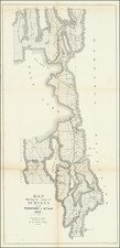
Finely detailed map of the area from Brown's Hole east of today's Vernal to the Great Salt Lake and south to below Fillmore.
The map locates the Emigrant Road to California.
Several Proposed Railroad lines are shown. One crosses the Green River near Black's Fork, continues past Fort Bridger (Wyoming) and along the Weber River to Ogden City where it turns south. Another railroad leaves the Wasatch Mountains via Timpanogas Canyon, and another heads west from the Oquirrh Mountains.
Wheat described this as an excellent map "due in large part to Egloffstein's work as Topographer for the Route."
Frederick Wilhelm von Egloffstein
Frederick Wilhelm von Egloffstein (1824 - 1885) was a German-born military man, explorer, mapmaker, landscape artist and engraver. He was the first person to employ ruled glass screens, together with photography, to produce engravings.
Egloffstein was the fifth and last son of Baron Wilhelm von Egloffstein and his second wife Karoline Marquise de Montperny.
Baron F. W. von Egloffstein was serving in the Prussian army as a lieutenant in the 5th (von Neumann or First Silesian) Battalion of Rangers (Jäger) in Görlitz, Prussian Silesia, in 1846 when he left for the United States. On August 31, 1846, Egloffstein arrived in Baltimore with his future brother-in-law Ernst von Kiesenwetter, with the intent to go to Texas, but seems to have settled in New Orleans.
By 1852 he was surveying properties and publishing maps as a partner of one G. Zwanziger, including a map of Bellefontaine Cemetery and another of western St. Louis County as a promotion for the Pacific Railroad of Missouri. Egloffstein was hired as a topographer for the last Western expedition of John Charles Frémont, 1853-54. He left the expedition in Parowan, Utah, after near starvation and exposure in the mountains, and went to Great Salt Lake City with his friend and colleague, the Daguerreotypist Solomon Nunez Carvalho. In Great Salt Lake City he joined the survivors of the Gunnison-Beckwith Expedition under Lieutenant Edward G. Beckwith, producing maps and panoramas of Utah, Wyoming, Nevada and California, published in the Pacific Railroad Reports.
After the completion of the Beckwith expedition, Egloffstein moved to Washington, DC, where he helped edit volumes of the Pacific Railroad Reports and began experimenting with new ways to portray terrain by taking photographs of plaster models.
In 1857-58 Egloffstein was one of two artists, along with Balduin Möllhausen, on the Joseph Christmas Ives expedition up the Colorado. Since by that time the US was deeply embroiled in a great civil war, the report received little attention. It was not until the 1880s, when public knowledge of the magnificent Grand Canyon had grown appreciably, that the report received greater recognition. It contained the first written descriptions of the Canyon's inner areas, as well as maps, panoramas, and illustrative plates by expedition artist, Friedrich W. von Egloffstein. His maps are now regarded as among the finest produced in the nineteenth century, using a half-tone system of his own invention.
Ives' report contains three engravings and three panoramic line drawings describing the "Big Caňon" of the Colorado. One particular stunning depiction was titled "Black Caňon" by Egloffstein himself, and has generally been understood to depict the section of the Colorado River where Hoover Dam now stands.
Students of Egloffstein's work have been baffled by the apparent errors, since Egloffstein was superbly competent - the 1861 report also contains a meticulous and accurate relief map of the Grand Canyon which Egloffstein produced on the trip. It was not until 2001 that an explanation for the discrepancies began to be developed: Jeremy Miller, viewing Egloffstein's Black Cañon in a New York exhibition, recognized it not as a portion of the Grand Canyon, but as part of the Gunnison River in present-day Colorado. He found the topographical map of that area which Egloffstein had produced for the Gunnison expedition, and noted that what is now called the Gunnison River was marked "Grand River" thereon. He found another Egloffstein work, View Showing the Formation of the Cañon of the Grand River, which had been produced during the Gunnison expedition. He then traveled to the Gunnison River and located sites which duplicated the vistas shown in the Egloffstein engravings of the nineteenth century. It is now presumed that Congressional staffers working on the 1861 Grand Canyon report misfiled the Egloffstein works, assuming that his "Grand Caňon" engravings must refer to The Grand Canyon expedition.
During the Civil War he produced a large map in his contoured style showing the Four Corners region for a report that was only published decades later. It shows paths of all major explorations in the region up to that time.
In 1864 he would publish a study of the mineral resources of the state of México based on reports done in the 1820s by his long-term friend, Baron Friedrich von Gerolt, Prussian Minister to the United States. His maps for this book are regarded as outstanding examples of half-tone and color map-making and display.
Egloffstein patented a method for photographically creating half-tone printing plates, which he sought to exploit commercially in the 1860s and 1870s, but with little commercial success. He continued working as an engraver and maker of scale models until his departure from America in 1878.
![[Moab, Utah / Oil] Oil Field Moab Area Utah / Embar Oil Company](https://storage.googleapis.com/raremaps/img/small/71812.jpg)
![[Large panoramic view of Salt Lake City] La Nouvelle Jerusalem, ou La Grande Ville du Lac Sale (Amerique).](https://storage.googleapis.com/raremaps/img/small/77721.jpg)