|
||

|

|
|

|
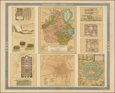
Striking Plan of the Templo Mayor de Cempoala (Zempoala) in the state of Veracruz
This late-nineteenth century plan shows the larger temple of Cempoala, also known as Zempoala. It is an important archaeological site for Mesoamerican history, but also for the history of the Spanish Conquest and for the practice of archaeology in modern Mexico.
The plan adopts a clean, architectural style with a stylized title. Set on a scale of one inch to seven meters, it depicts the Zempoala compound, including the structures of the Main Temple, the Temple of the Chimneys, the Temple of the Air, the Grand Pyramid of Three Bodies, the Pyramid of Two Bodies, and the Temple of Little Faces. Each structure is meticulously and clearly labeled with upper case letters which are explained in a key to the lower right. These point out staircases, benches, platforms, vestibules, and murals.
The site
Zempoala derives from Cēmpalli, meaning "Place of Twenty Waters" or "abundant water." These waters refer not to the Gulf of Mexico, which is nearby, but to aqueducts that hydrated the gardens and fields of the site or, possibly, to local streams. The ruins are located in what is now the Úrsulo Galván Municipality in the state of Veracruz, eastern Mexico. It is roughly six kilometers from the Gulf of Mexico and just over a kilometer from the Rio Actopan, otherwise known as the Rio Chachalacas.
The buildings surveyed here are still standing today. The Main Temple has its top surrounded by battlements. The Great Pyramid is also known as the Sun Temple and resembles the temple of the same name in Tenochtitlan. It has three rings inside it that may have been used to calculate astronomical events. The Temple of Chimneys is named not for chimneys, but for a series of pillars that resemble them.
Finally, the Temple of Little Faces is a bit farther off than the rest of the compound, to the right, or east, on the plan. It has stucco reliefs around the walls. The name refers to the hundreds of stucco skulls that at one time decorated the façade of a structure at the foot of the temple's staircase. Experts believe this area was dedicated to the god of death. Inside, there are murals showing astronomical bodies like the sun, moon, and the star Venus. There are also more clay faces inside.
The surveyors
This plan was drawn up by two members of the Corps of Engineers, part of the Mexican Army. The army had trained engineers since 1822, but the training had not been constant or consistent due to the young country's turbulent politics. By 1891, when this plan was made, the Corps of Engineers was grouped with the Colegio Militar, the Military Academy, and was expected to produce the best and the brightest the Army had to offer. The engineers were tasked with many projects, including the creation of a carta general of the Republic. Their Colonel, Agustín Díaz, was also the founder of the Comisión Geográfica Explorada. Engineers, trained in drafting and surveying, were sent all over Mexico to take measurements and gather information.
Little is known about the two surveyors listed here, Second Capitan Pedro P. Romero and Lieutenant Fernando Castillo. Romero seems to have continued in the army until at least the Mexican Revolution.
Pre-conquest and conquest history
The site was inhabited by a variety of peoples over time, including Totonacs, Chinantecas and Zapotecs. According to some sources, the city was originally founded at least 1,500 years before the Spanish arrival, and there is evidence of Olmec influence. Although not much is known about the Preclassical and Classic Era, the Preclassical town was built on mounds to protect it from floods.
The Totonacs arrived around 1050 AD, forcing out the Toltecs who had already developed settlements in the area. At their height, the Totonac Empire supported 250,000 people across 50 towns. The Totonacs ruled the empire of Totonacapan which consisted of the northern part of Veracruz together with the Zacatlán district of Puebla. Zempoala had a population of between 25,000 and 30,000. The main buildings were constructed between 1300 and 1500 AD.
The Aztecs proved a formidable foe and the Totonacs were defeated by Montezuma by 1458 AD. Totonacapan became a tributary state, forced to pay taxes and offer humans as sacrifices and slaves to Tenochtitlan. This situation bred resentment on the part of the Totonacs.
When the Spanish arrived in 1519, the Totonacs were only too ready to seek revenge. They allied with the Spaniards and together these two groups formed an army that marched on the Aztec capital. However, life was no better under the Spanish. The Totonacs were banned from practicing their religion, relocated, and enslaved. Smallpox raged through the population, further weakening it. By 1575, Zempoala was abandoned.
Archaeology at Zempoala
After the smallpox epidemic, the site fell into disrepair and relative oblivion. Only in the late nineteenth century, under the tenure of Francisco del Paso y Troncoso, was it uncovered and began to be excavated. A native of Veracruz, Paso y Troncoso studied the Nahuatl language and archaeology; he was so interested in the subject that it resulted in his not receiving his medical degree. In the late 1880s he was appointed head of the National Archaeological Museum. In 1890 and 1891, he led a massive archaeological exploration of Veracruz, of which the excavations at Zempoala, and this plan, were most likely a part. The site was left alone again until Garcá Payón returned to excavate in the 1940s. Excavation continues today, with new temples and structures being uncovered.
“Los Ingenieros Militares en el México Independiente”, http://repositoriodigital.academica.mx/jspui/bitstream/987654321/183867/1/LOS%20INGENIEROS%20MILITARES%20EN%20EL%20MEXICO%20INDEPENDIENTE.pdf
![(Mexican-Aztec Paintings) [Original watercolor of Aztec Deities: Panquetzaliztli, Atemoztli, Nemontemi, and others]](https://storage.googleapis.com/raremaps/img/small/103006.jpg)
![[ Cabo San Lucas, Southern Baja ] Delineatio Nova Et Vera Partis Australis Novi Mexici, cum Australi Parte Insulae Californiae Saeculo Priori ab Hispnis Detectae.](https://storage.googleapis.com/raremaps/img/small/95666.jpg)