|
||

|

|
|

|
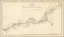
Manuscript Plan of Land Disputed for Decades by Indigenous Peoples in Oaxaca
This is a copy of a plan of several haciendas in the state of Oaxaca. It is one manifestation of a half-century long land dispute between an indigenous village and the Esperón family of landowners.
Rather than focus minutely on the haciendas in question, the map takes in a broad sweep of the surrounding land, which is mountainous. The altitude is marked with hachures, which are interrupted by plentiful streams branching from the rivers running through the area. The map is west-oriented as indicated by the colorful compass rose in the upper right corner. The fields of the haciendas are carefully laid out in bright green, with buildings in black and pueblos in pink.
Several tables list the size of the agricultural land in each of the haciendas concerned: el Rosario, San Vicente, la Concepción, San Jose, and San Antonio. Each roman numeral or letter corresponds to one of the fields hugging the river. A note below the table outlines the area of the lands involved.
In the lower left, there is a key detailing the houses, estates, villages, churches, huts, rivers, ravines, pathways, corrals, (cane) fields, streams, hills, rises, summits, and a boundary line. A sentence next to the key reveals the boundary to denote land that was adjudicated in 1856. The town council of Tlaxiaco has granted the land to the Señores Esperónes.
The text at the right of the plan explains that this a copy of the 1856 plan, which is held in the archives of the Municipality of Tlaxcalo. Forty years later, the copy of the plan needed to be verified by witnesses as being an exact copy. This copy will now be placed in the municipal archive as well, although it is not clear why a copy was needed. The text was written, signed, and stamped in 1898. The notary involved was Francisco Javier Mejia and the judge was José C. Pardo.
The banality of this act is actually one of the final steps in many years of litigation between the Esperóns and the local people. Originally, the land belonged to the indigenous Mixtec pueblo of Santa María Yucuiti. Tlaxiaco had long tried to control the lands near the river. They did have ownership of some of the cañas, but not the hillsides. In two instances, the Spanish Crown ruled in favor of Yucuiti. However, in 1856, the same year as the original plan, the Lerdo Law, or disentailment law, abolished corporate property. The Esperóns, a powerful political family in Oaxaca, asserted political pressure on the Tlaxiaco council, which renewed ownership of the land and then sold it to the Hacienda de la Concepción, owned by the Esperóns. For the next thirty years, the Esperóns and the pueblo litigated access to and use of the land. The Esperóns{ ties to the borlados, moderate liberals in Oaxaca, and the pueblo's support for Porfirio Diaz tied the struggle over the land to the struggle for Mexican politics.
In the late 1880s, Esteban Cházari Esperón, who is the witness who verifies the plan in 1898, inherited La Concepción. At this time, the town, led by Mateo Máximo López, renewed its efforts to defend its lands, marked in pink near La Concepción on the plan, by arguing that the pueblo owned the land via a group of individuals, not a corporate entity. During this period, Cházari lived in Mexico and La Concepción was managed by Gustavo Stein, also mentioned in the text. In 1895, the hacienda evicted some villagers, but the people returned a few days later.
Stein escalated the dispute by complaining about the village to the Governor of Oaxaca and the German delegation in Mexico City. In 1896, the village was granted title to the disputed lands and La Concepción was told to pay rent to the town. The dispute continued into the twentieth century, ending only after the Mexican Revolution.
The area in question fell under the control of the municipality of Tlaxiaco. Located in a valley in the Mixteca region, the town was given the name "Heroica" Ciudad de Tlaxiaco in honor of the battle fought there in resistance to the French invasion of the 1860s.
Transcription of the explantion:
El Ciudadano Lic. José C. Pardo, Juez constitucional del Distrito, actuando por receptoría á falta de Notario público, Certifico; que el presente plano es copia fiel de su original que existe en el Municipio de esta ciudad y el mismo a que se refiere el acta de confrontación levantada en esta fecha en el Protocolo de mi cargo y con cuyo testimonio se entrega el presente al Ciudadano Estéban Chazari, certifico igualmente que la calificación que se ve al reverso del mencionado plano original día a la letra; El Ciudadano Licenciado Francisco Javier Mejia, Notario público de número de esta Ciudad=Certifica: que según instrumento otorgado ante mí en esta fecha, por el Municipio de esta Ciudad y el Sr Gustavo Sthein como apoderado general de los Señores Esperon de este comercio, reconocer ambas partes que el presente plano de las Hacienda Concepción, San Vicente, San José, San Antonio y el Rosario, que señala los límites y extensión de terrenos que en la actualidad tiene en propiedad la casa Esperón, es el legítimo y verdadero que comprende la extensión de los mismos terrenos que fueron vendidos por este Municipio a favor de aquella, según escrituras de nueve de Octubre de mil ochocientos cincuenta y seis conforme a las aclamaciones de límites que en el referido instrumento de hoy se hicieron, mencionar y a la que se sujetan las dos paras en lo sucesivo; así mismo certifico que el presente plano es el que queda en el archivo del Municipio de esta Ciudad: Doy fe Tlaxiaco, Marzo veinte siete de mil ochocientos ochenta y nueve=Francisco J. Mejía=Rúbrica. Esta certificación está autorizada con el sello del Notario público y la estampilla de ley. El testimonio da conformidad firman la presente razón de C. Presidente municipal, Sindico y Secretario del Ayuntamiento en Tlaxiaco a cuatro de Octubre de mil ochocientos noventa y ocho. Doy fe.
Jose C. Jarell
C. Chájim
Manuel Villeger Lago
Rafaél Cruz Torriba
Julio de Suarez
Salvador Gómez Añorve
Samuel R. González
Octubre 4 1898
![Map of Mexico, Central America, and the West Indies [Insets of Bermuda, Sandwich Islands, Jamaica and Panama Railroad]](https://storage.googleapis.com/raremaps/img/small/78369.jpg)
![[ Mexico ] [Painted map of Mexico and the Southern United States by a Noted Artist who studied mural painting under David Siqueiros]](https://storage.googleapis.com/raremaps/img/small/101948.jpg)