|
||

|

|
|

|
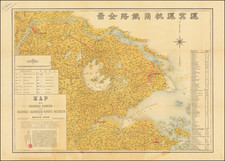
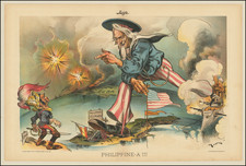
Fine example of the second state of Ortelius' map of China, the first western map of China.
Ortelius' map of China is taken directly from reports of the Portuguese mapmaker Luis Jorge de Barbuda (Ludovicus Georgius), who made a manuscript map of China which reached Ortelius via Arias Montanus. First published in 1584, Ortelius' map of China is the earliest printed map to focus on China and the first to illustrate the Great Wall of China. Tooley referred to the map as the standard map of the interior of China for over sixty years. With its three lushly designed cartouches and many illustrations of indigenous shelters, modes of transportation and animals, this is one of Ortelius's richest engravings.
When this map appeared, it was by far the most accurate representation of China to appear on a printed map. Japan is shown on a curious curved projection reminiscent of Portuguese charts of the period with Honshu dissected along the line of Lake Biwa. The Great Wall is shown, but only a relatively small section, its length is significantly underestimated. The Tartar "yurts" are dotted across the plains and steppes of Central and East Asia.
The Portuguese Jesuits established a mission in China in 1577. Although the map's Portuguese maker, Barbuda, was himself not a Jesuit, his sources for the map were Portuguese Jesuits. The Chinese characters found in the text on the verso of the map were the first introduction to Chinese language for many educated Europeans of the time.
There are three states of the map.
- State 1: Pre-dates the words "Las Philippinas" above Sinus Magnus
- State 2: Las Philippinas added during the publication of the 1587 French edition (second state)
- State 3: Additional cross hatching in one of the wind wagons, which first appeared on the map during the publication of the 1595 edition
1608/1612I118 (300 copies printed) (last line first text page, right aligned: sempio, ; last line second text page, right aligned: last line second text page, left aligned, in cursive script like 25 lines above it: "scelta libreria del Padre Posseuino pur della compagnia delli Iesuiti ambodue."),
Abraham Ortelius is perhaps the best known and most frequently collected of all sixteenth-century mapmakers. Ortelius started his career as a map colorist. In 1547 he entered the Antwerp guild of St Luke as afsetter van Karten. His early career was as a business man, and most of his journeys before 1560, were for commercial purposes. In 1560, while traveling with Gerard Mercator to Trier, Lorraine, and Poitiers, he seems to have been attracted, largely by Mercator’s influence, towards a career as a scientific geographer. From that point forward, he devoted himself to the compilation of his Theatrum Orbis Terrarum (Theatre of the World), which would become the first modern atlas.
In 1564 he completed his “mappemonde", an eight-sheet map of the world. The only extant copy of this great map is in the library of the University of Basel. Ortelius also published a map of Egypt in 1565, a plan of Brittenburg Castle on the coast of the Netherlands, and a map of Asia, prior to 1570.
On May 20, 1570, Ortelius’ Theatrum Orbis Terrarum first appeared in an edition of 70 maps. By the time of his death in 1598, a total of 25 editions were published including editions in Latin, Italian, German, French, and Dutch. Later editions would also be issued in Spanish and English by Ortelius’ successors, Vrients and Plantin, the former adding a number of maps to the atlas, the final edition of which was issued in 1612. Most of the maps in Ortelius' Theatrum were drawn from the works of a number of other mapmakers from around the world; a list of 87 authors is given by Ortelius himself
In 1573, Ortelius published seventeen supplementary maps under the title of Additamentum Theatri Orbis Terrarum. In 1575 he was appointed geographer to the king of Spain, Philip II, on the recommendation of Arias Montanus, who vouched for his orthodoxy (his family, as early as 1535, had fallen under suspicion of Protestantism). In 1578 he laid the basis of a critical treatment of ancient geography with his Synonymia geographica (issued by the Plantin press at Antwerp and republished as Thesaurus geographicus in 1596). In 1584 he issued his Nomenclator Ptolemaicus, a Parergon (a series of maps illustrating ancient history, sacred and secular). Late in life, he also aided Welser in his edition of the Peutinger Table (1598).
![(Southeast Asia) [Unpublished Manuscript Sailing Directions from Europe to China by a French Navigational Officer]](https://storage.googleapis.com/raremaps/img/small/90507.jpg)