


|
||

|

|
|

|
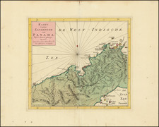
Manuscript map of Central America, including the never-conquered Moskito Coast
Finely executed map of a large portion of Nicaragua and Honduras, extending from from Punta Marabique, in modern Honduras, to the Costa Rican coast beyond the Río de San Juan, likely drawn during the period of time between 1787 and 1804, when the region was nominally under the control of the Captaincy General of Guatemala.
This map likely dates from the late eighteenth-century, just after the Spanish had (temporarily) re-claimed control over the region as part of the Captaincy General of Guatemala. The map was almost certainly prepared at the request of the local colonial authority, rather than by an official Spanish Naval survey team. Unlike the coastal charts then being prepared by the Spanish Royal Navy, this map focuses on the major navigable rivers, topography and location of cities and towns, while the details of the coastline are relatively simple and naive, in comparison to Spanish sea charts of the period for this region.
Although most likely intended as a tool of colonial government, the map actually shows how tenuous a hold the Spanish had over the region. Spanish sovereignty was always in question along the Mosikito Coast, the area pictured here. The people of the Moskito Coast maintained their own government, commerce, and culture based on their multiracial society forged in opposition to the Spanish.
Central America and the Spanish Empire
As the title explains, this is a map of part of the Central American coast from Punta Marabique, in modern Honduras, to the Costa Rican coast beyond the Río de San Juan. The map extends from Amatique Bay in the west around Cabo de Gracias a Dios and then turns southward along the Moskito Coast, now in Nicaragua.
As there are no political sub-divisions shown, the map would seem to show the Captaincy General of Guatemala, also known as the Kingdom of Guatemala. Founded in 1609, it was an administrative division of the Spanish Empire encompassing the present-day nations of Costa Rica, Nicaragua, Honduras, El Salvador, Belize, Guatemala, and the Mexican state of Chiapas. The Captaincy was dissolved in 1821 when Guatemala, El Salvador, Honduras, Nicaragua, and Costa Rica declared their independence from Spain.
The Diverse Moskito Coast
The map shows rivers extending into the interior and some towns, including San Pedro (Sula) and Comayagua. In addition to towns marked with red dots and green rivers, there are a few notes. One on the Moskito Coast reads, "southernmost point of the entrance to the lagoon called Bluefieles." This refers to Bluefields, a bay and town established by Dutch pirate Abraham Blauvelt, who lent his name to the place. The note is but one of several clues on the coast that this area was frequented and settled by diverse peoples. Another clue are the two places labeled ' poblaci ón ingles' and ' poblaci ón inglesa', as well as one ' poblaci ón de moros'. The entire coast is called ' Territorio de Negros, Sambos, y Moscos.' These names indicate the presence of indigenous, English (or non-Spanish European), and black groups.
The ' moscos' and the name Moskito Coast refer to the Tawahara Miskitu people, an Ameridian group who live along the coast. When the Spanish expanded their influence in Central America in the sixteenth and seventeenth centuries they were unable to conquer the coast, despite numerous attempts. Instead, the area became a pirate haven predicated on harassing Spanish trade; the buccaneers, particularly the English, traded with the local indigenous peoples.
By the mid-seventeenth century, Africans, the moros and negros referred to on the map, had joined the population as either shipwrecked or escaped slaves fled to the area and began to settle and intermarry with the indigenous population. Also in the mid-seventeenth century, an English company, the Providence Island Company, began to trade with the Moskito from their base on Providence Island in the Caribbean. In 1740, the coast became a British protectorate, a strategic territory from which to interrupt the Spanish American monopoly. The British presence thrived due to an alliance with Moskito leaders and support from Jamaica.
Over time, a group of Afro-indigenous people known as zambos, or sambos, became powerful, taking positions of leadership within what the British called the Moskito Kingdom. The zambos led raiding parties that ranged from the Yucatán to Costa Rica; they sold their captives to the British to be used as slaves in Jamaica. During the War of Jenkins Ear (1739-48), the British and Moskito worked together to attack their common enemy.
The alliance was hobbled at the end of the American Revolution when British territorial claims were ceded to Spain. From 1787 to 1804 the area was nominally under the control of the Captaincy General of Guatemala. It seems likely that this map was made during that period as part of a report for the colonial government. The number 6 near the title indicates it may have been part of a series of cartographic images, perhaps of the entire Captaincy. However, in 1804 the Moskito revolted. British influence returned and was a constant throughout the nineteenth century.
Rarity
While 18th Century Spanish manuscript sea charts of this region are relatively scarce, this map, with its focus on the internal regions, is even more unusual, both in terms of its focus and the probability that it was an indigenous product.
We find no comparable manuscript works from this period.
Baron L. Pineda, Shipwrecked Identities: Navigating Race on Nicaragua's Moskito Coast (New Jersey: Rutgers University Press, 2006).
David Weber, Barbaros: the Spanish and their Savages in the Age of the Bourbon Reforms (New Haven: Yale University Press, 2005).

![[Galapagos] Carte de la Cote Occidentale D'Amerique Comprise Entre Le Golfe de Tehuantepec et le Golfe de Guayaquil (Amerique Centrale, Nlle Grenade, Equateru) . . . .1864](https://storage.googleapis.com/raremaps/img/small/57942.jpg)
![[Fruit Crate Label Advertising Map] Panama Brand (North America & Panama Canal)](https://storage.googleapis.com/raremaps/img/small/48860.jpg)