|
||

|

|
|

|
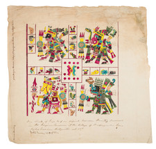
Rare Second State of Carmelite Province of Mexico in Blue Ink
This is a very rare map of the central area of Mexico, illustrating the Discalced Carmelite convents of both friars and nuns and engraved by Domenico Franceschini. This is a rare second state in blue ink, differentiating it from other surviving copies. The first edition of this map came out in 1739; this is an updated state from ca. 1747.
The map shows the central section of Mexico, which roughly covers (west to east) the modern Mexican states of Michoacán, Mexico, Tlaxcala, Puebla, and Veracruz. North to south it shows the region from San Luis Potosi to Oaxaca (Antequera). Three small insets are tucked into the borders of the map: Cuba to the northeast, Guatemala to the southeast, and Peru to the southwest. Together, this huge area represents by far the largest province of the Discalced Carmelites.
The map gives a sense of altitude with the inclusion of mountains from a bird's eye view. The hydrology of the province is shown via branching rivers and lakes labeled with their names, including the now drained lakes around Mexico City. A decorative cartouche in the upper right corner includes a full-figure portrait of Saint Albert, a patron of the order.
Across the bottom of the map is a large key that lists the convents of friars (Conventus Fratrum) and of nuns (Conventus Monalium), and the convents of Peru (only since the nineteenth century has the word 'convent' referred more exclusively to communities of religious women). For the houses of friars in Mexico, the mapmaker has also included their year of establishment, from Mexico City in 1586, to Guadalajara, Tehuacán, and San Luis Potosi in 1747. It is the inclusion of dates for these three that differentiates this state from the original. In the 1739 state they are listed without dates as 'Hospitia.' This state shows the rapid expansion of the order in just a decade.
The map was created to show the latest province added to the Spanish Discalced Carmelite Congregation. The Mexican province was added to the six existing provinces in 1588, as explained in the title cartouche in the upper right corner. The other six provinces at that time were Castilla la Vieja, Castilla la Nueva, Andalucia la Alta, Andalucia la Baja, Aragon and Portugal.
The map was part of a book on the Spanish Discalced Carmelites Provinciarum et Conventuum Fratum, ac monalium Discalceatorum Ordinis B Virginis Mariae de monte Carmelo Congregationis Hispaniae Corographica Topographica, et Chronologica Descriptio, published in Rome over the course of eleven years, 1739 to 1750. The author of the book is Giovanni Battista, but the engraver of the map is Domenico Franceschini. Franceschini was from a family of Italian engravers active in the eighteenth century.
The book was meant as a geography and history of the order. The earliest origin of the Carmelite order is traced to a group of hermits living on Mount Carmel. In the early thirteenth century, the hermits requested St. Albert of Jerusalem, Papal legate, for a Rule. Albert laid out sixteen articles which became the foundation for the Carmelite Order. After leaving the Near East due to conflict, the Carmelites established houses in England, France, Catalonia, and elsewhere in Europe. The order of Carmelite nuns was approved by papal bull in 1452 and the first nuns in Spain came in 1479.
The Discalced, or Barefoot, Carmelites emerged from a movement in Spain in the 1560s and represented a return to a more eremitical existence. The Discalced Carmelites were recognized as a separate province of the Carmelite Order in 1580. Only six years later, their first Mexico house, in Mexico City, was founded. The first convents were established in Puebla de los Angeles and in Mexico City in the early seventeenth century. Eventually, both cities would have two convents, as indicated by the key on this map.
The map is very rare on the market, this being only the second example we have seen and the only example in blue ink.
![El numero 1 q[ue] se haya en la orilla de la ???ya que corre a San Ysidro es el gran ?? de partida siguencio? la numeracion immediata a los puntos amarillos ?on los ?inderos, hasta? el numero 19 con que vierra en el terreno marcados con la letra C.](https://storage.googleapis.com/raremaps/img/small/65664ba.jpg)
![(Mexican War) [ Proposed United States - Mexico Military Border - January 1848 ]](https://storage.googleapis.com/raremaps/img/small/99246.jpg)