|
||

|

|
|

|
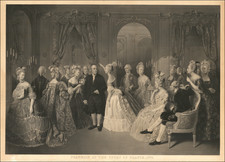
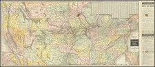
Striking example of this monumental 4-sheet map of North America, issued shortly after the conclusion of the Revolutionary War.
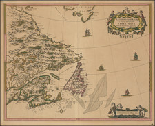
Originally issued separately by Bowen & Gibson in 1755, this map was periodically updated following the conclusion of the French and Indian War and the American Revolution. Beginning in 1775, it was bound into some of the most influential American Atlases of the era, including those issued by Jefferys, Faden and Sayer & Bennett. Beginning in the late 1770s, the map was updated to include surveys compiled by Governor George Pownall, including information from Evans' and other indigenous sources. Included on the map is an inset of Hudson's Bay and an inset based upon Fra. Eusebio Kino's explorations to the mouth of the Colorado River.
The title "United States" appears on the portion of North America allocated by the 1783 Treaty, while in the top right corner of the upper sheet is a four-line note about the coast of Labrador and Article III of the Treaty.
The map is packed with Indian placenames in the west, forts along the Mississippi and west of the Appalachians, and full compliment of annotations on early roads, explorations and other geographically specific facts. The title cartouche has been strengthened from previous issues and features fine cross-hatching of the Indian figures and animals.
A visually striking example of this four sheet wall map of North America.
Robert Sayer (ca. 1724-1794) was a prominent London map publisher. Robert’s father was a lawyer, but his older brother married Mary Overton, the widow of prominent mapmaker Philip Overton and the proprietor of his shop after his death. Mary continued the business for roughly a year after her marriage and then, in early 1748, it passed to Robert. Robert became a freeman of the Stationers’ Company later that year; his first advertisement as an independent publisher was released in December.
Sayer benefited from Overton’s considerable stock, which included the plates of John Senex. In the 1750s, Sayer specialized in design books and topographical prints, as well as comic mezzotints. In 1753, he, along with John Roque, published a new edition of Thomas Read’s Small British Atlas, the first of several county atlases that Sayer would publish.
Sayer’s business continued to grow. In 1760 he moved further down Fleet Street to larger premises at 53 Fleet Street. In 1766, he acquired Thomas Jefferys’ stock when the latter went bankrupt. In 1774, he entered into a partnership with John Bennett, his former apprentice. The pair specialized in American atlases, based on the work of Jefferys. They also began publishing navigational charts in the 1780s and quickly became the largest supplier of British charts in the trade.
Bennett’s mental health declined, and the partnership ended in 1784. As Sayer aged, he relied on his employees Robert Laurie and James Whittle, who eventually succeeded him. He spent more and more time at his house in Richmond. In 1794, he died in Bath.
![Carta rappresentante una parte della Baja Hudson, e le Regioni a Maestro dell'America Settentrle. [Map representing a part of Hudson Bay, and the regions to the northwest of North America.]](https://storage.googleapis.com/raremaps/img/small/95989.jpg)