
This item has been sold, but you can enter your email address to be notified if another example becomes available.


|
||

|

|
|

|
Stock# 49127
Description
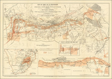
Rare separately issued folding map of South Africa, published by John Bartholomew in Edinburgh.
The map includes a primary map of South Africa, covering the Cape Colony South African Republic, Orange Free State, the western part of Portugese East Africa, and a small section of German South-West Africa.
The large inset at the top left shows parts of Natal, Transvaal and the Orange Free State, centered on Newcastle, Dundee and Ladysmith.
A second large inset is centered on Johannesburg, the Witwaterrand Gold Fields and Pretoria.
The inset at the bottom left shows parts of Cape Colony and the Orange Free State, centered on Kimberly.
The map is quite rare. We note only a single example of the map in OCLC (University of Michigan).
Condition Description
Dissected and laid on linen. Title on paste down, marbled end papers.
![North Africa [with] South Africa](https://storage.googleapis.com/raremaps/img/small/48322.jpg)