|
||

|

|
|

|
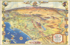
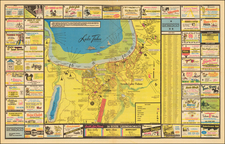
Rare early pictorial map of Yosemite Valley, by Lowell Butler.
Prepared for Westways Magazine, the magazine of the Southern California Automobile Club, the map provides an automobile centric map of Yosemite, but also includes early trails and of course the most famous tourist destinations in Yosemite National Park. A nice mix of tourist facts and whimsical imagery.
Lowell Butler created pictorial maps for publications of the Automobile Club of Southern California in the mid 1950s, including A Map of the Marked Historical Sites of California (c. 1952), Outdoor Play Places of California (c. 1954) and Spanish California: A Map of the Missions, Presidios, Pueblos and Some of the More Interesting Ranchos (c. 1956).
The present map would seem to be one of the earliest recorded Lowell Butler illustrations. The earliest image listed by Rumsey was done in 1952, although we also note Butler's Joshua Tree map of 1937: /gallery/detail/44159
The map is apparently quite rare. We find no other references to this map.