This item has been sold, but you can enter your email address to be notified if another example becomes available.


|
||

|

|
|

|
Stock# 48903
Description
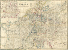
Fascinating eclipse map, utilizing a Sepia overprinting for the map of Europe, with the progressive intensity of the Solar Eclipse of April 1, 1764 shown.
The map shows, in advance, the path of the eclipse, one of the earliest printed maps to show the anticipated course of a solar eclipse.
The map title translates as:
Helio-Seleno-European Graphic Map showing the Projection that the shadow of the Moon will trace on the surface of this part of our Globe in the famous Central and Annular Eclipse of the Sun that will arrive on the 1st. April 1764.
The map is extemely rare. We locate only the copy at the Bibliotheque National de France.
Condition Description
Soiled and offset, with some ink staining at the bottom right.