


|
||

|

|
|

|
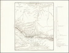
Striking full color example of Humboldt's landmark map of Texas, Mexico and the Southwest.
Humboldt's map is one of the five most important and influential American maps of the 19th Century and the single most important map of the region prior to Disturnell's map. Wheat regarded it as a truly magnificent cartographic achievement…for the area of the American West which it included, it was undoubtedly the most important and most accurate published map that had yet appeared. '
Streeter noted that Humboldt's map was one of the six most important maps for a Texas collector and remained the standard map of the Great Basin region until Fremont's expeditions 35 years later. Streeter 1042. Pike had access to the information left by Humboldt in the US for his work and according to Humboldt plagerized his work, as did Arrowsmith.
Humboldt notes in his accompanying text many contemporary American and Spanish sources from which he gathered data and manuscript material. Without doubt, the map was the most widely disseminated and influential map of the period.
![(Texas and California) The Whig Almanac and United States Register for 1843 [bound with:] The Whig Almanac and Politicians' Register for 1845 [bound with:] The Whig Almanac, and Politicians' Register for 1846 [with maps of Texas and Oregon] [bound with:] The Whig Almanac: 1847.](https://storage.googleapis.com/raremaps/img/small/87041.jpg)
![(California and Mexico) [Album of 68 original photographs (including 42 panoramic views): a train wreck in California; San Francisco earthquake damage; Torreon; Aguascalientes; Mexico City and more]](https://storage.googleapis.com/raremaps/img/small/98220.jpg)