|
||

|

|
|

|
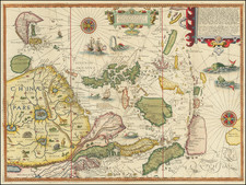
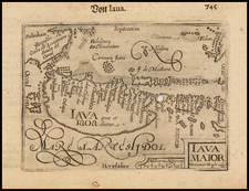
The Most Important Map of the Kingdom of Siam Published In the 17th Century
A landmark map of Siam and environs, based upon the French Embassy to the region in 1685.
The map depicts the arrival of the first French embassy to the Kingdom of Siam, in what is now Thailand. Dechaussé dedicates the map to the Chevalier de Chaumont, who led the delegation. Dechaussé's map depicts the route from just west of the Sunda Straits, through the Banca Straits, then past Bintang Island and up the east side of the peninsula via the Gulf of Siam.
The delegation arrived in 1685. The Siamese King, Narai, wished to manage European contact with his country and preferred the French to the Dutch and English. In 1680, the Siamese attempted to establish an embassy in France but were thwarted when the ambassador's ship was wrecked off Mauritius. They succeeded in sending a delegation in 1684. In an audience with King Louis XIV, the Siamese requested an embassy be established in Siam. Louis responded favorably, sending the Chevalier de Chaumont the following year.
There are several states of the map which have small differences in the title and the second title at the bottom:
- Title: Par P. Du-Val, Geographe Ordinre. du Roy . . . Second Title: A Paris Chez I Besson en l'Isle Palais sur le Quay de l'horologe a la Couronne d Or Avec Priv du Roy pour 20. Ans 1686
- Title: Par le R.P. Placide, Augustin Dechausse, Geographe ordinaire de su Majeste . . . Second Title: A Paris Chez Mlle. Du Val Niesse de l'Auteur, sur le Quay de l'horologe a la Couronne d Or Avec Priv du Roy pour 20. Ans 1686
- Title: Par le R.P. Placide, Augustin Dechausse . . . No second title
The changing titles reflect the development of the Du Val map business. Pierre Du Val was one of the foremost mapmakers in France in the second half of the seventeenth century. Trained by his uncle, the famous mapmaker Nicolas Sanson, Du Val was named Geographer to the King in 1650. After his death in 1683, Du Val's business was carried on by his widow and daughters. They were aided by his brother-in-law, the R[évéren]d Pere (R. P.) Placide, Augustin Dechaussé. Dechaussé assumed the title of Geographer to the King. He died in 1724.
This is the second state of the map, published by Mademoiselle Du Val, Dechaussé's niece, in the same premises that her father had occupied. As stated above, Du Val died in 1683. It is likely he started or had already made a map of Siam and surrounding countries prior to his death, while Dechaussé likely added the route of Chaumont and made other improvements. The map thus captures a moment of political importance, the first French embassy to Siam, and of cartographical historical significance, the evolution of a prominent mapmaking business.
Rarity
The map is very rare on the market. This is first example we have ever offered for sale.
Pierre Duval (1618-1683) was a French geographer, cartographer, and publisher who worked in Abbeville and Paris during the seventeenth century. He was born in the former city, in northeast France, before moving to Paris. Duval was the nephew of the famous cartographer Nicolas Sanson, from whom he learned the mapmaker's art and skills. Both men worked at the royal court, having followed the royal request for artists to relocate to Paris. In addition to numerous maps and atlases, Du Val's opus also includes geography texts. He held the title of geographe ordinaire du roi from 1650 and died in 1683, when his wife and daughters took over his business.
Brother-in-law to Pierre Du Val. He helped Du Val's widow and daughters continue the business after Du Val's death in 1683, assuming the title Geographer to the King.