|
||

|

|
|

|
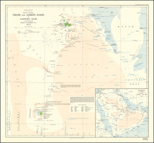
Scarce separately issued Spanish Sea Chart of a section of the east and west coast of Africa, Madagascar, the coastline of Arabia, Red Sea, and west coast of India, extending to the Maldives.
The chart is colored to show the location of lighthouses in yellow.
At the right, there is evidence that the chart was used to chart a course in the Gulf of Guinea and near the islands of Saint Helena, Ascencion and Tristan da Cunha.
The Dirección de Hidrografía, or the Directorate of Hydrographic Works, was established in 1797. Its roots were in the Casa de Contratación, founded in 1503 in Sevilla, which housed all the charts of the Spanish Empire and oversaw the creation and maintenance of the padrón real, the official master chart. The Casa, now in Cadiz, was shuttered in 1790, but Spain still needed a hydrographic body. In response, the Dirección was created in 1797. One of its first projects was the publication of charts from the Malaspina Expedition (1789-1794). The Dirección oversaw not only publication, but also surveying. The Dirección was abolished in the early twentieth century, when their work was distributed to other organizations.