|
||

|

|
|

|
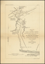
A Western Rarity
Rare military map of Montana, North Dakota, South Dakota and Minnesota, with contigous parts of Wyoming, Idaho and Nebraska, published by the United States Corps of Topographical Engineers.
This is the most advanced map of Montana published to date, drawing on a wide array of important government maps (listed below).
A fine example of this remarkable map, which was the result of field observations and compilations drawn from numerous sources by the commanding officers of the Department of the Dakota. The map was apparently a separately issued map prepared for military use and was almost certainly not available to the public, which would explain its rarity. These maps were typically circulated only to high ranking military officers and surveyors operating in the region, for the express purpose of working with a compilation of the best available information and, in turn, periodically supplmenting and updating the information with field observations.
A subdivision of the Division of the Missouri, the Department of Dakota was established by the United States Army on August 11, 1866 to encompass all military activities and forts within Minnesota, Dakota Territory and Montana Territory. The Department of Dakota was initially headquartered at Fort Snelling, Minnesota, and then moved to St.Paul in March 1867. The department was discontinued in 1911.
The map is updated from the 1886 map of the Department of Dakota: /gallery/detail/29824
The map was issued in the months after the Massacre at Wounded Knee, South Dakota in December 1890.
The primary Military Posts are identified with an American Flag and Star, and include:
- Ft. Missoula
- Ft. Yellowstone
- Ft. Custer
- Ft. Assiniboine
- Ft. Meade
- Ft. McKinney (not star)
- Ft. Keogh
- Camp Poplar River
- Ft. Buford
- Ft. Yates
- Ft. Sully
- Ft. Pembina
- Ft. Snelling
The areas depicted in green outline are Indian Reservations and include the following:
- Flathead
- Blackfoot
- Ft. Belknap
- North Cheyenne
- Gros
- Fort Peck
- Forth Berthold
- Standing Rock
- Cheyenne River
- Lower Brule
- Crow Creek
- Devil's Lake
- Turtle Mountains Band
- Red Lake Unceded Indian Lands
- Bois Forte
- Caso Lake
- Chippewa
- Whilte Earth
- Siseton and Wahpeton
- Fond Du Lac
US The map includes a list of maps used to compile the present map, including:
- Department Map of 1886 (Lt. John Biddle)
- Map of the Military Departments of Columbia and the Platte
- United States Land Office Maps
- United States Postal Route Maps
- Canadian Land Office Map of Manitoba and the North West Territory
- Land Office Map of the Eastern Part of British Columbia
- Rail Road Surveys
- Maps of Yellowstone National Park Geological Survey
- Maps, Itineraries and Reports by Officers of the Department
The map is significantly larger than the 1886 map, adding counties, wagon roads, trails, railroads, railroad stations, and significant additional details.
Battle fields are depicted with crossed swords.
The full title of the map is:
Map of the Department of Dakota. Including Minnesota, North Dakota, Montana, Yellowstone National Park and that Portion of South Dakota, Lying North of the Forty-Fourth Parallel of North Latitude. Prepared by Authority of Brigadier General Wesley Merritt in the Engineer Office Hdqrs. Dept. Dakota. Compiled and Drawn Under The Direction of Lieut. Haydn S. Cole 3rd Inf. A.E.O. By H.F. Strebe. Topographical Asst. U.S.A. 1891.
Haydn S. Cole
Haydn S. Cole (1861-1939) graduated from West Point in 1885, after attending school at the University of Illinois and Yale. He was commissioned a second lieutenant, Third Infantry, at Port Ellis, near Bozeman, Montana.
Port Ellis was abandoned a year later, and the Third Infantry was transferred to Fort Custer. There Cole's duties were varied and included one period of field service against the Crow Indians. At that time, Custer was the headquarters of the First Cavalry.
While on a visit to St. Paul, Minnesota, in February, 1888, he was requested to join the staff of General Ruger as Chief Engineer Officer of the Department of Dakota. After a few months duty at Fort Snelling, he joined General Ruger's staff.
After retirement from the military, he decided to take up the practice of law in St. Louis, but soon returned to St. Paul, where he practiced law and became a part of the business community, serving again as an officer during World War I.
General Wesley Merritt
Wesley Merritt (1836 - 1910) was a general in the United States Army during the American Civil War and the Spanish-American War. He served with distinction in the cavalry in the Civil War and Indian Wars. He was the first American Military Governor of the Philippines in August 1898 until being relieved to advise the United States delegation in the peace negotiations.
Following his engagements in the South during the Civil War, in June 1865, Merritt was appointed commander of Cavalry Forces of the Military Division of the Southwest. After the war's end, Merritt continued to serve in the cavalry along the frontier. He was appointed lieutenant colonel of the newly raised U.S. 9th Cavalry on July 28, 1866, and in July 1867 was sent to command Fort Davis, Texas, garrisoned by six of the regiment's companies. He was made colonel of the 5th Cavalry on July 1, 1876, which he commanded in the Battle of Slim Buttes during the Indian Wars.
As colonel of the 5th Cavalry, Merritt was a member of the court of inquiry which first sat on January 13, 1879, which was convened to consider the behavior of Major Marcus A. Reno of the 7th Cavalry at the Battle of the Little Bighorn (June 25 to 26, 1876); which resulted in the death of General George Armstrong Custer and over 200 men of the 7th Cavalry.
He served on the frontier until being appointed superintendent of West Point, a post he filled from 1882 to 1887. From July 5, 1887 to July 9, 191, he served as the commander of the Department of the Dakota, during which time strikes occurred on the Northern Pacific and Great Northern Railroads, which were promptly put down.
Rarity:
The map is extremely rare. OCLC locates only the copy at the Minnesota Historical Society. We also note on-line entries for Boston Public LIbrary and Yale.
This is the first example to appear on the market, with no other auction or dealer catalog records.