This item has been sold, but you can enter your email address to be notified if another example becomes available.


|
||

|

|
|

|
Stock# 48658
Description
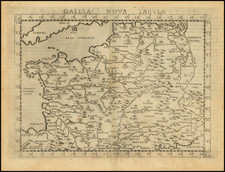
Scarce regional map of Lorraine and Bar-le-duc, with east oriented at the top of the map.
The map is centered on the Moselle River, including Metz, Nancy, Saarbrucken, Luxembourg, Verdun, Bar-le-duc, and Neufchateau.
Christopher Tassin Biography
Nicolas Tassin (fl. 1633-55) was appointed 'royal cartographer' at Dijon before setting up as an engraver in Paris where he issued various collections of small maps and plans of France, Switzerland, Germany and Spain. Tassin first published his maps in his own atlas Cartes Generale de Toutes Les Provinces de France in 1634, with an enlarged second edition in 1637 (France, royaumes et provinces d'Europe).
![[ France ] Galliae Regionis Nova Descriptio](https://storage.googleapis.com/raremaps/img/small/81285.jpg)
![(Ancient France) Gaule; sous l'empire des Romains, devenue France, par les conquetes de Clovis, 1er roi chretien, en 481; divisee en provinces, jusqu'en 1789 [Gaul, Under the Roman Empire, which becaem France by the Conquests of Clovis, the first king of France in 481; divided in provinces until 1789]](https://storage.googleapis.com/raremaps/img/small/81959.jpg)
![[ France ] Galliae seu Franciae Tabula, qua omnes Provinciae, Viae angiariae, et aliae res notatu dignae distincte et accurate ostenduntur . . .](https://storage.googleapis.com/raremaps/img/small/98436.jpg)