
This item has been sold, but you can enter your email address to be notified if another example becomes available.


|
||

|

|
|

|
Stock# 48603
Description
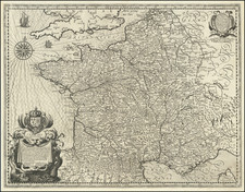
Rare map of the Dauphine / Alps Region of France, published in Paris circa 1640.
The map is oriented with south at the top, centered on Grenoble.
Major cities appearing on the map include Lyon, Briancon, Valence, Gap, etc.
Christopher Tassin Biography
Nicolas Tassin (fl. 1633-55) was appointed 'royal cartographer' at Dijon before setting up as an engraver in Paris where he issued various collections of small maps and plans of France, Switzerland, Germany and Spain. Tassin first published his maps in his own atlas Cartes Generale de Toutes Les Provinces de France in 1634, with an enlarged second edition in 1637 (France, royaumes et provinces d'Europe).
![[Napoleon's Battles in France, Belgium Netherlands, Luxembourg, Germany] No. 1 Frontiere du Nord. Mesny 5.](https://storage.googleapis.com/raremaps/img/small/60727.jpg)
![(French Naval Dry Docks) Marine, Plan des Formes Baties a Rochefort pur la Construction des Vaisseaux du Roy [Navy, Plan of Locks Built at Rochefort for the Construction of Royal Vessels]](https://storage.googleapis.com/raremaps/img/small/88594.jpg)