|
||

|

|
|

|
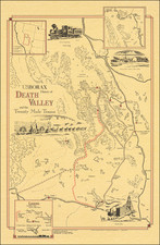
An Important Map Illustrating The Irrigation Canals of Kern County, with manuscript annotations locating Well Claims
Important early map of a part of Kern County, published by Britton & Rey.
The map focuses on the natural and man-made hydrographical features of the region, providing a remarkable overview of the region at the time when two of its competing business interests, the Kern Valley Water Company Canal (Lux & Martin) and the Kern County Land & Water Company (Haggin, Tevis & Carr), were squaring off in an effort to capture available Riparian and Appropriative Water Rights for the waters in this part of Kern County.
The map illustrates the Kern Valley Water Company Canal, west of the so called Tule Lake Swamp District, a massive region of wetlands created by the receding waters of Tulare Lake, as well as the Calloway Canal. These competing canal owners would, within 2 years, launch a series of 84 lawsuits which would establish the California Doctrine, the water law doctrine which would determine the water rights of land owners in California, Washington, Oregon, North Dakota, South Dakota, Nebraska, Kansas, Oklahoma and Texas.
The map extends from Kern Lake in the north to Delano in the south and from Bakersfield in the east to Tulare Lake in the west.
The locations of a number of wells are marked in pencil and in some instances the owners name is given. Sloughs and canals are shown and also the Central Pacific R.R. The wells noted in pencil consist of approximately 30 wells, mostly around the Calloway Canal. While most of the wells are not identified further, the following wells are named:
- Brode Camp
- Noriega Well (Faustino Mier Noriega was a sheep herder, likely of Basque descent)
- Martin Well
- Chapman (Chapman Ranch)
- Jarvis? Well
- Abandoned? Well
Faustino Mier Noriega was a sheep herder, likely of Basque descent, who sold his land to the Kern County Land Company.
Kern County Water Rights & Wetlands Litigation and "The California Doctrine"
The focal point of the map is the explosive growth of the Canal system to the south and west of Bakersfield. The map illustrates the growth of irrigation in the Valley following the creation of the Kern County Land & Water Company in 1875, by James Ben Ali Haggin, Lloyd Tevis and William B. Carr. The growth of the Valley and its agricultural business accelerated following Congressional passage of the Desert Land Act0 of March 3, 1877, a congressional measure intended to stimulate farming in the arrid lands of the West.
Haggin and his company would acquire hundreds of thousands of acres of land in the Bakersfield area, including a large tract of land on the Kern River above Bakersfield, where the river emerges from the Sierra Nevada mountains and the development by the Kern County Land & Water Company of the Calloway Canal in 1877 and ulimately a total of 27 canals in the area.
Beginning in 1879, rival land owners would form the Riparian Suits Association and initiate a total of 84 lawsuits against Haggin, seeking to adjudicate the competing rights of Haggin and the interests represented by the Association. Much of the litigation was driven by Miller and Lux and their rival Kern Valley Water Company, who were seeking to exploit the water in the Buena Vista Slough by diverting the waters which created this wetlands to the dry farming regions to the west. The litigation became the most important dispute between Riparian and Appropriative water rights in the west.
The litigation went to trial in 1881 and shaped water rights law and usage in the region for many years to come, determining the relative rights of Riparian and Appropriative water rights, as well as the rights of owners with wetlands. The result is the so-called California Doctrine.
The California Doctrine of water law, established in the California Supreme Court ruling in Lux v. Haggin, attempted to blend the two doctrines by endorsing the riparian right as the law of the land, but outlining the circumstances under which the appropriative right could be held as superior. Under Lux v. Haggin , all private lands as well as public lands upon transfer to private ownership held riparian rights, but first priority could be given to an appropriator if the appropriative right had been established before riparian rights.
Provenance: Warren Heckrotte Collection.
![[Southern California Views] Delightful Southern California, The Land of Sunshine and Bloom](https://storage.googleapis.com/raremaps/img/small/74862.jpg)
![[San Joaquin Valley] Valley of Kah Wee Ya River (Four Creeks)](https://storage.googleapis.com/raremaps/img/small/90289.jpg)