


|
||

|

|
|

|
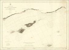
The Pantoja Map of San Diego Bay
Juan Pantoja's map of San Diego Bay is perhaps the single most important early charting of San Diego Bay. Surveyed between August 28 and September 28, 1782, during the expedition of Juan Pantoja y Arriaga, it has been described by Harlow as "the first reliable chart of [San Diego] Bay."
The present manuscript map is without question the first real map of San Diego Bay and by far the most influential. As noted by Harlow:
Pantoja's chart was not only the first to show the Bay's "true appearance," but --with the subsequent addition of False Bay--was the most prolific of imitation, with and without attribution, by English, Spanish, French, Mexican, German Russian and American nationals for the next 60 years.
This map is one of several fruitful results of a voyage to supply Spanish settlements in California in 1782. Under the command of Esteban José Martinez, two vessels, the Princesa and the Favorita, were instructed to search for the newly founded mission of Santa Barbara. Two journals of this voyage are extant, one by Martinez, and the other by Juan Pantoja y Arriaga, his pilot. The ships first landed in San Francisco Bay and proceeded southwards, stopping at Monterey, Point Concepçion, Santa Barbara, and arriving at San Diego Bay August 21, 1782. While some of the crew were set to work on the mission church, Pantoja set out to survey San Diego Bay, before the ships began their return to San Blas.
As noted by Sothebys in is 2010 catalog entry for this map:
The present map differs from the versions in Mexico City and Madrid, in that it is oriented with north to the left, and the scale is slightly larger "6 maritime miles in 60 degrees"(ca. 1:103,000), while in these others, the scale is 5 (ca. 1:136,800). These characteristics are similar to those of a version presented by the explorer Juan Francisco de la Bodega y Quadra to the Viceroy of Mexico, the Conde de Revilla Gigedo, now in San Diego (UCSD, Hill Collection, no. 1298). The Hill Collection map is described as "This unique Spanish manuscript map of the San Diego region, the only version of the Pantoja map to depict the Coronado Islands and the projected Fort Guijarros on Point Loma ..." two features which also appear on the present map (at letters Q and B respectively). It is reproduced in H. P. Kraus, Catalogue no. 144: The American West Coast and Alaska, no. 42.
The original version of the map was copied and distributed to Spanish sea captains, and some were passed to English captains as well. This is not surprising as there was a need in both navies for the most accurate maps, particularly those marking shoals and soundings in harbors (the two powers were not currently at war, and the information was not secret). While possession of the region was then in dispute, captains shared information, and there was a well-organized group of cartographers in San Blas, creating copies for distribution to naval officers.
Pantoja and the Early Maps of San Diego
In total, Pantoja is credited with 3 charts of San Diego Bay from this and a subsequent expedition, including a later chart of 1786, which was later copied by Dalrymple and Espinosa y Tello and others (Harlow #5), and a sketch map in the Museo Naval in Madrid (Harlow #6).
The supply ships Princesa and Favorita, under the command of Juan Pantoja, anchored inside Point Guijarro on August 21, 1782. Pantoja's survey commenced on August 28. By September 7, he had fixed compass bearings and on September 10, he set out on a smaller boat with an assistant and crew to undertake a close observations. The expedition spent 5 days closely observing the coastal features of the harbor. Thereafter, buoys were set in the channel "to better ascertain depth and the flow of tides."
As Pantoja noted in his journal, prior to his observations, no prior work had been done to make a close study of the harbor. The only prior surviving charts of the harbor were two simple sketchs done by Geronimo Martin in 1602 or 1603, from an original sketch undertaken during the Sebastian Vizcaino expedition (the expedition that named San Diego Bay) and a small crude topographical map of the Bay, drawn during one of the first visits to San Diego Bay following the establishment of the Mission San Diego, typically credited to Vincente Vila, commander of the San Carlos, from whose diary and letter of July 6, 1769 the map is extracted.
Early History of San Diego
San Diego was discovered in 1542 by Juan Rodriguez Cabrillo. The original name was San Miguel. It was next visited by Sebastian Vizcaino in 1602, at which time it was re-named San Diego, when he was mapping the coastline of Alta California for Spain in 1602. While Vizcaino was enthusiastic about its prospects, it would be another 167 years before San Diego was colonized, with the founding of the Mission San Diego de Alcala and Presidio of San Diego, the first Mission and Spanish settlement in Upper California.
The earliest colonists in San Diego arrived in 1774. In 1775, the Kumeyaay Indians rebelled against the Spanish. They killed the priest and two others, and burned the mission. Junipero Serra oversaw the reconstruction of the Mission, which was completed in 1780. By 1797 the mission had become the largest in California, with a population of more than 1,400 "Mission Indians".
Provenance : James S. Copley Library; Purchased from V.O. Wahrenbrock, November 11, 1966: /gallery/enlarge/48446a
Lynda Claassen, head of UC San Diego Special Collections Library also reports ownership of a Pantoja manuscript map of San Diego Bay as of September 2016, although the copy inspected as of the time of this catalog entry.

![[Mexico and Central America with Baja California inset, from Generalkarte von Nord America samt den Westindischen Inseln Versasst von Herrn. Pownall . . . MDCCLXXXVIII]](https://storage.googleapis.com/raremaps/img/small/95064.jpg)
![[Southern California] Map of Automobile Roads Banning California](https://storage.googleapis.com/raremaps/img/small/45357.jpg)