|
||

|

|
|

|
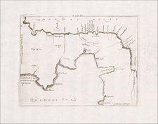
Rare Contemporary Broadside of Vernon's Attack on Portobelo, Panama
Rare separately published broadside map of the Battle of Porto Bello, one of the first primarly battles between Britain and Spain during the War of Jenkins' Ear, published by Thomas Bowles in London.
Portobelo was one of the most important Spanish colonial cities in America. It served as a strategic Spanish transfer point for gold and silver coming from South America.
Portobelo was long the object of desire for pirates and privateers. After taking part in a failed attempt to capture a fully laden Spanish treasure ship departing from Portobelo in 1727, Vice Admiral Edward Vernon made claims that he could capture the historic port with just six ships. In November 1739, Vernon organized a squadron of six ships to capture the settlement. Due to strong easterly winds, Vernon was initially forced to focus his efforts on the harbor fort (here labeled The Iron Castle).
Vernon's attack caught the Spanish off guard and his forces quickly gained control of the fort, forcing the Spanish to surrender. Subsequently, Vernon shifted his efforts to the town of Portobelo, which he also catured.
The capture of Portobelo was seen as a big triumph in Britain and America, and the names Portobelo and Vernon were widely celebrated and commemorated in Britain, including Portobelo Road in London, the Portobelo district of Edinburgh, and Mount Vernon in Virginia, the home of George Washington. "God Save the King," as it is known today, was first sung at a dinner given in honor of Admiral Vernon's successful siege of Portobelo. The British occupied Portobelo for only three weeks, destroying the fortress and key buildings before withdrawing.
Bowle's rare view locates five of Vernon's ships (Norwich, Burford, Strafford, Worcester and Hampton Court), engaged in battle with the
Iron Castle, on the point, with numerous Spanish soldiers on land that appear to be retreating. The sixth ship, Princess Louisa, appears at bottom left, just ouside of the bay. The town of Portobelo appears at top right, with the fortified
Gloria Castle adjacent to the town, firing its cannons upon the encroaching British ships. Spanish ships guard the city. A lettered key identifies the ships and key locations.
Below the view is "'An account of Admiral Vernon's taking Porto Bello, as published by Authority." The account is based on letters written from Vernon to Thomas Pelham-Holles, the Duke of Newcastle and Secretary of the State, which were dispatched to London by Captain James Rentone on December 12, 1739, arriving in London on March 13, 1740. The account describes the lead-up. to the battle beginning on November 5, 1739, the battle itself, and the aftermath through December 7, 1739.
This broadside is very rare. We note only the examples in the British Library and John Carter Brown Library.
![[Central America]](https://storage.googleapis.com/raremaps/img/small/77960.jpg)
![Carte Des Antilles Du Golfe Du Mexique et d'une partie des Etats voisons…1842 [Republic of Texas]](https://storage.googleapis.com/raremaps/img/small/98848.jpg)