This item has been sold, but you can enter your email address to be notified if another example becomes available.


|
||

|

|
|

|
Stock# 48122
Description
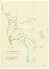
Detailed map of San Francisco in 1866, oriented with west at the top.
Includes a detailed treatment of San Francisco, naming streets, squares, public buildings, churches, parks, etc.
The contours of the coastline, before the landfill along the bay was added, can still be seen.
A list of 4 Rail Road (street car) lines is included, including:
- Front St. Ocean & Mission RR (Summit of Telegraph Hill)
- Central RR (Summit of Russian Hill)
- North Beach & Mission RR (Summit of Clay St. Hill)
- Ominbus RR (Summit of California and Sacramento St.)
This is the first time we have seen this map offered for sale, although it likely comes from an early travel guide.
![[Esparto, California] Map Showing Subdivisions of the Bonynge Tract and the Position of the Townsite of Esperanza Yolo County California... 1887-1888](https://storage.googleapis.com/raremaps/img/small/83457.jpg)
![(Early California Trade) [Royal Decree of October 22,1803, to encourage trade in California]. D. Joseph de Yturrigaray, Caballero profeso de la Orden de Santiago, Teniente General de los Reales Exércitos, Virrey, Gobernador...Con fecha de 22 de Octubre del año proximo anterior...la Real Orden...Con objeto de fomentar la Agricultura y Comercio de las Californias, se ha servido el Rey habilitar sus Puertos en calidad de menores...](https://storage.googleapis.com/raremaps/img/small/93851.jpg)