
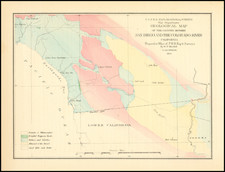
![[ Southern California Water Explorations ] Topographical Sketch showing the Outward and Inward Route of A Party, while examining the practicability of a Diversion of the Colorado River for Purposes of Irrigation under the Command of 1st Lieut. Eric Bergland Corps of Engineers, U.S. Army 1875 By George M. Wheeler](https://storage.googleapis.com/raremaps/img/small/98208.jpg)


|
||

|

|
|

|
Highly detailed US Geographical Survey Map, tracing the expedition route from Ehrenberg and the Willow Spring area to Los Angeles, via the Coachella Valley and San Bernardino, the North into the Mojave Desert and on toward modern day Las Vegas.
The map is one of the earliest obtainable detailed maps of the Los Angeles Basin, Inland Empire, Mojave Desert and Las Vegas areas.
The purpose of the expedition, as noted by the title of the map, was to investigated the prospect of diverting water from the Colorado River, in order to promote farming in the Imperial Valley, etc., one of the earliest investigations of the feasibility of this concept.
The map provides a very early look at the road system and topographical features of Southern California, on the eve of Southern California's first big land boom in the 1880s.
![[Mexico and Central America with Baja California inset, from Generalkarte von Nord America samt den Westindischen Inseln Versasst von Herrn. Pownall . . . MDCCLXXXVIII]](https://storage.googleapis.com/raremaps/img/small/95064.jpg)

![[First Obtainable Map to Name California] Tartariae Sive Magni Chami Regni typus](https://storage.googleapis.com/raremaps/img/small/82510.jpg)