|
||

|

|
|

|
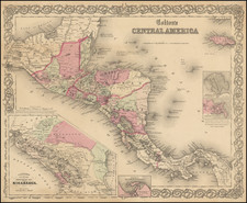
Amsterdam edition of Antonio de Herrera y Tordesillas' map of the Audiencia of Panama, from his Descripcion de las Indias Occidentalis, first published as part of his Historia General, in Madrid in 1601.
This map is the earliest printed Spanish map to depict Central America. The lack of detail in the interior reflects the Spanish policy of secrecy, which precluded the dissemination of geographical knowledge, a policy strictly and apparently affectively enforced, as prior to Herrera's work, no Spanish printer made any attempt to provide meaningful detail for this region.
Centered on Panama, the map provides coastal and river details of a region of historical significance as one of the primary gateways between the Caribbean and the Pacific Ocean.
The first edition of Herrera's work is of the utmost rarity and the plates were never again used. The maps were copied in Amsterdam in 1622 and after.
![[Unusual Italian Immigrant Communities shown!] America Settentrionale, Centrale e Meridionale -- Carta Dimostrativa Delle Ambasciate, Legazioni, Consolati (Con Le Risettive Circoscrizioni Territoriali), Camere Di Commercio, Agenzie Commerciali, Stazion Enotecniche, Uffici Postali, Ospedali, Scuole Governative e Sussidiate All'Estero](https://storage.googleapis.com/raremaps/img/small/86098.jpg)