|
||

|

|
|

|
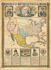
Richly colored example of this scarce late version of Melish's map of the United States, from the Jackson Wreath.
The map extends westward to depict the northwest, Missouri and "Arkansa" territories, and the province of Mexico, including Texas.
Very early appearance of the name Oregon Territory, extending from the Mississippi River westward.
The map draws extensively from Lewis & Clark, Pike, Humboldt and others. The genesis of this map begins in 1812, with its issuance in pocket map format by Melish.
The map was improved, reissued and slightly expanded for a number of works over the next two decades, this being one of the last appearances of the map.
John Melish (1771-1822) was the most prominent American mapmaker of his generation, even though his cartographic career lasted only a decade. Melish was born in Scotland; he moved to the West Indies in 1798 and then to the United States in 1806. By 1811, he had settled in Philadelphia and published Travels through the United States of America, in the years 1806 & 1807, and 1809, 1810, & 1811, which was richly illustrated with maps.
Melish created several regional maps of the highest quality, as well as the Military & Topographical Atlas of the United States (Philadelphia, 1813, expanded 1815). The latter work is widely considered to be the finest cartographic publication to come out of the War of 1812.
By far his best-known work is his monumental map of the United States of 1816, Map of the United States with the contiguous British and Spanish Possessions. He began working on the map in 1815 and sent it to Thomas Jefferson for comment in 1816. Jefferson enthusiastically reviewed the map and returned it with his edits. Jefferson later hung an example of the map in the Entrance Hall of Monticello and sent it to associates in Europe.
Melish’s finished product was the first map of the United States to extend to the Pacific Ocean. After its publication in 1816, Melish ensured the map was as up-to-date as possible; it was reissued in 25 known states published between 1816 and 1823. The map captured the then rapidly changing geography of the United States, as well as various boundary disputes, treaties, and expansion.
![[ Military Departments ] Johnson's New Military Map of the United States Forts, Military Posts & all the Military Divisions with Enlarged Plans of the Southern Harbors . . .](https://storage.googleapis.com/raremaps/img/small/101114.jpg)