|
||

|

|
|

|
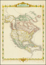
The British View of the Louisiana Purchase.
Detailed map of North America, illustrating an Anglo-centric view of the land acquired by the United States in the Louisiana Purchase.
The map illustrates two features which give away its political view. The first feature is the termination of "Louisiana" and the United States at the Rocky Mountains. The second is the undefined boundary between British Canada (extending south toe "New Albion) and Spanish California.
California is New Albion and New California. The Great Salt Lake is called "Great Shell L." Curiously, the Russian settlements on the coast of California are also ignored.
The Upper Missouri reaches hopefully for a water route to the Pacific, with no sign of Lewis & Clark's crossing the Rocky Mountains. The Columbia River is tentatively shown after the first 50 miles or so, with a poor treatment of Puget Sound.
From Smith's General Atlas.
![A New Map of North America Shewing its Principal Divisions, Chief Cities, Townes, Rivers, Mountains &c. Dedicated to His Highness William Duke of Gloucester [California as an Island]](https://storage.googleapis.com/raremaps/img/small/100578.jpg)