|
||

|

|
|

|
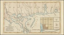
Scarce early map of East & West Florida, shortly after the end of the French & Indian War.
The map is one of the very best examples of Florida depicted as an Archipelago, in a time period prior to the British Survey of Florida in the 1770s, under the direction of Gerard De Brahm, the first systematic survey of the region.
Includes an inset map, "Plan of the Harbour and Settlement of Pensacola".
Following the conclusion of the French & Indian War and Seven Years War, the English acquired Florida, as part of a reordering of possessions by the colonial powers.
In 1763, Spain traded Florida to the Kingdom of Great Britain for control of Havana, Cuba, which had been captured by the British during the Seven Years' War. Almost the entire Spanish population left Florida, taking along most of the remaining indigenous population to Cuba.
The British divided the territory into East Florida and West Florida. The British soon constructed the King's Road connecting St. Augustine to Georgia. The road crossed the St. Johns River at a narrow point, which the Seminole called Wacca Pilatka and the British named "Cow Ford", both names ostensibly reflecting the fact that cattle were brought across the river there.
The British government gave land grants to officers and soldiers who had fought in the French and Indian War in order to encourage settlement. In order to induce settlers to move to the two new colonies, reports of the natural wealth of Florida were published in England. A large number of British colonists who were "energetic and of good character" moved to Florida, mostly coming from South Carolina, Georgia and England, though there was also a group of settlers who came from the colony of Bermuda.
In 1767, the British moved the northern boundary of West Florida to a line extending from the mouth of the Yazoo River, east to the Chattahoochee River, consisting of approximately the lower third of the present states of Mississippi and Alabama. During this time, Creek Indians migrated into Florida and formed the Seminole tribe.
The two Floridas remained loyal to Great Britain throughout the American Revolutionary War. However, Spain (participating indirectly in the war as an ally of France) captured Pensacola from the British in 1781. In 1783, the Treaty of Paris ended the Revolutionary War and returned all of Florida to Spanish control, but without specifying the boundaries. The Spanish wanted the expanded boundary, while the new United States demanded the old boundary at the 31st parallel north. In the Treaty of San Lorenzo of 1795, Spain recognized the 31st parallel as the boundary.
The Gentleman’s Magazine was a British publication that helped to normalize the use of maps in support of articles and features. It was founded in 1731 by the prominent London publisher Edward Cave, a pioneer in periodical journalism. The magazine continued in print for nearly two centuries, shuttering production in 1922.
This was the publication which first used the word “magazine”, from the French for storehouse. Cave wanted to create a storehouse of knowledge and he employed some of London’s best writers to fill his pages: Samuel Johnson gained his first regular employment by writing for the Gentleman’s Magazine. Other famous contributors included Jonathan Swift.
The publication covered a broad range of topics, from literature to politics, and, from 1739, frequently used maps as illustrations. The first map they printed was a woodcut of Crimea; the second was a fold-out map of Ukraine by Emanuel Bowen. Maps were used to show battle lines, to chronicle voyages, and to educate about areas with which Britain traded. Certain geographers, like Thomas Jefferys, contributed several maps to the publication.


![[ Florida Native Americans Cultivating & Planting ] Culturae & sationis ratio.](https://storage.googleapis.com/raremaps/img/small/98211.jpg)