This item has been sold, but you can enter your email address to be notified if another example becomes available.


|
||

|

|
|

|
Stock# 47847
Description
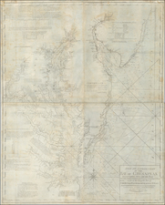
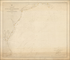
Nice example of th e Atlas Minor edition of Hondius' 1606 map of the coastline between Virginia and northern Florida, including the Carolinas and Georgia.
The map is based upon the work of John White and Jacques LeMoyne, as interpeted by De Bry's maps of the explorations. One of the last maps to cartographically predate Smith's contribution and the settlement of Jamestown. Le Moyne's lake in Florida has been moved to central Florida, to accomodate the St. May (St. Johns) River, which flows easterly. The influence of Wytfliet and Ribaut are in evidence.
The map retains much of the detail of the larger version of the map, including all of the Indian village names.
Reference
Burden 155.