|
||

|

|
|

|
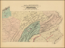
Remarkable American Canal Map & Profile Showing The Proposed Route of the Susquehanna and Tidewater Canal
Previously unrecorded first state of this finely executed map and elevation profile view, showing the proposed course of the Susquehanna Canal & Tidewater Canal.
The detail with which the map is constructed is quite extraordinary, identifying not only the course of the proposed canal and the location of each lock, but also identifying land owners, towns, islands, ferrys, roads and bridges. The Old Maryland Canal (Port Deposit Canal) is also located, along with the railroad connections on either side of the Susquehanna River.
The construction of the profile view of the Canal is also quite extraordinary, showing the location of each, acqueduct and other features of the topography and canal.
Credited to Edward F. Gay, the chief engineer of the project, the map is both a work of meticulous detail and great rarity. E.F. Gay was involved in the construction of canals for several decades. As early as the 1821, he wa serving as an assistant engineer on the Erie Canal, overseeing construction of the canal from Albany to the crossing of the Mohawk River. He would go on to serve as the chief engineer for many other railroad projects in the region in the 1840s and 1850s, including the Columbia and Philadelphia Railroad, and later serve as president of the Philadelphia and Erie Railroad company, a position he would hold until the 1870s.
The Report of Edward F. Gay to the Commissioners of the Susquehanna Canal Company was made on June 5, 1835. At that time, the report contained a recommended route from Columbia to the Maryland border on the eastern side of the River only, with the intention of thereafter linking up with the Old Maryland Canal. On February 3, 1836, the Pennsylvania House Committee on Inland Navigation & Internal Improvement reported against the passage of bill S-29, which would permit the Susquehanna Canal Company to change from the east side to the west side of the river, based upon a fear that if the canal is built to Havre-de-Grace, it can be continued without interruption to Baltimore, whereas if built to Port Deposit, traffic could be taken more easily to Philadelphia. However, by March 21, 1836, Pennsyvlania had reversed its position and approved the change from the east to the west bank. On April 1,1836, Maryland approved a connection with the proposed Canal from the state line to Havre-de-Grace.
The map provides a meticulous look at the proposed route of the canal, during the early stages of its conception. It is also noteworthy that the map shows the route of the canal entirely on the east side of the river, with no reference to the crosssing of the Ferry as noted in the excerpt below. As reported in 1836 in the Hazard's Register of Pennsylvania . . . (Vol 16, page 343-44)
THE SUSQUEHANNA CANAL FROM COLUMBIA TO TIDE.
Mr. Gay, the Chief Engineer, is now engaged making a final survey of the first twelve miles of this important work, commencing at Columbia, and extending along the east bank of the river to Burkholder's Ferry. It is expected the whole of this distance will be ready for letting by the first of December, and that the work will be prosecuted with the utmost vigor throughout the winter. The general width of the Canal will be 50 feet at the water line, and five feet deep. Where excavations are through rocky precipices, it is probable the width will be reduced, which will be amply compensated, by the frequent occurrence of indentations, or natural short bays of the river, by running the sea walls or river embankments in nearly a direct line from point to point, which, while it will shorten the embankments, will present, occasionally, fine sheets of water, affording ample space for landings, and allow the boats to pass with greater speed.
From Buckholder's Ferry to Tide, there is an opinion, founded on actual survey, that the Canal can be constructed at a much less cost, on the West than on the East side of the river; and, consequently, be kept in repair at a much less expense. The situation for a landing, for wharves and for a port to facilitate trans-shipment, is unquestionably preferable on the Havre-de Grace side, than at any point that can be selected on the Eastern shore.
It is to be regretted, that so much delay has been occasioned by fruitless attempts to come to an understanding with the proprietors of the Maryland Canal. The work will now, however, progress; and should the obstacles to an amicable adjustment between the two companies continue, the public interest will not suffer by changing the Southern division of the Canal to the West side of the river, however it may operate to the disadvantage of a few interested individuals.
The annexed article from the Baltimore American, shows the estimation in which the citizens of Baltimore hold the plan of connecting the valley of the Susquehanna with the Chesapeake Bay, by a continuance of the PennsyIvania Canal from Columbia to Tide. Great as are the advantages contemplated, we do not believe they are yet appreciated at one tenth their value. We may form some idea of the immensity of the Anthracite coal trade from the mines of Lykens's Valley. Pine Grove, and Luzerne, and the bituminous from Columbia, Clearfield, and Lycoming, by the Juniata and West Branch of the Susquejianna, and of the lumber trade; but we can form no estimate of the wheat, flour, corn, whiskey, tobacco, pork, beef, butter, lard, tallow, hemp, cotton, wool, furs, iron, lead, copper, &c. &c. which will pour from the North and West into the lap of commerce, the Great Chesapeake Bay, destined to become before long, the centre of the greatest trade in the world. That the Pennsylvania Canal will be totally inadequate to afford vent for the business which must offer in a very few years, is certain; and that the Chesapeake and Ohio Canal, and the James River and Kenhawa connection with the Ohio, instead of becoming injurious rivals to the Pennsylvania lines of canals and rail roads, will only prove useful auxiliaries, acting in concert, and relieving the immense business, east and west, from all apprehension of being interrupted or delayed by an inability to accommodate at all times the trade of which they are the destined channels.
We observe we have, perhaps without thinking of the full strength of the expression, denominated the Chesapeake Bay, "the Lap of Commerce." As regards the trade of the United States, nature has conspired to make it so, and human sagacity and foresight cannot neglect so magnificent a gift. View all its advantages its position in the centre of the Union-its numerous rivers, washing the richest vallies of three of the Atlantic States, and its immediate connection by different routes with the great West-What can prevent it be coming the centre of the commerce-of the wealth and strength of the Union?
The Susquehanna and Tidewater Canal
In the 1820s, in order to promote trade from the interior of Pennsylvania, residents of Baltimore proposed construction of a canal along the lower Susquehanna River, linking Chesapeake Bay to Pennsylvania's Main Line of Public Works at Columbia, Pennsylvania, across the river from Wrightsville. Residents of Philadelphia, fearing loss of trade to Baltimore, argued against the proposal. In 1829, completion of the Chesapeake and Delaware Canal across an isthmus south of Philadelphia, resolved the impasse by shortening the water link between Havre de Grace and Philadelphia to 74 miles. Since this was only 20 miles further by water than from Havre de Grace to Baltimore, the prospective Susquehanna and Tidewater Canal stood to benefit both cities.
On April 15, 1835, the Susquehanna Canal Company of Pennsylvania merged with the Tidewater Canal Company of Maryland, for the purpose of funding and building the canal. Construction began in 1836 and was finished in 1840. The finished canal between Wrightsville, Pennsylvania, and Havre de Grace, Maryland, at the head of Chesapeake Bay, provided an interstate shipping alternative to 19th Century arks, rafts, and boats plying the difficult waters of the lower Susquehanna River. The finished canal brought increased shipments of coal and other raw materials to both cities from Pennsylvania's interior. Competition from railroads was a large factor in the canal's decline after 1855.
Rarity
This would appear to be the first state of the map, which was apparently unrecorded. There are two clear differences between this edition and the second state. The present state bears the imprint "Watson's Lith. No. 62, Walnut St., Phild." at the bottom of the center sheet and does not include the note at the bottom left of the left sheet, which describes the Canal dimensions.
The map is very rare. We locate examples of the second state in the British Library and Maryland Historical Society, but the first state is apparently unknown.