


|
||

|

|
|

|
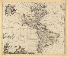
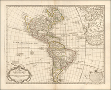
De Wit’s Map of the Americas—The First Dutch Map to Show Five Great Lakes
Fine example of De Wit’s map of the Americas, first published ca. 1675. It was the first Dutch map to include all five Great Lakes, an improvement on De Wit’s first map of the Americas (1660) and his wall map of 1672. This example is a state unrecorded by Burden.
The map includes both North and South America, as well as much of the Pacific. It is based on De Wit’s earlier two maps of the continents, as well as draws on Guillaume Sanson’s map of North America, published in 1669.
California is depicted as an island. The west coast of Hudson Bay has been updated since De Wit’s earlier maps. The interior of North America shows the political demarcations between empires. There are also many animals to fill the vast plains, including bears, foxes, and wolverines. Of most interest, though, are the five large lakes in the Midwest of the continent, Lac Superieur (Lake Superior), Lac des Puans (Lake Michigan), Mare Dulce (Lake Huron), Lac Erie (Lake Erie), and L. de S. Louis (Lake Ontario).
South America includes the Strait of Le Maire with a small Staten Landt and an open-ended island east of the Straat de Brouwers, a suggestion of the still-elusive southern continent. The many riverine networks are a striking feature of the continent, while the indigenous village and a battle being waged with bows and arrows in Brazil are also prominent.
The map includes two highly-decorative cartouches, which are drawn from Nicolass Jansz. Visscher’s map which was first published in ca. 1658. The first, shown in the upper right corner, is held up by a series of Christian figures. An angel pulls the cartouche away as an evil, clawed figure emerges from below. Above the clawed figure is a pure woman wearing a billowing dress, holding a cross to cast away the devilish figure. Helping the angel is what is supposed to be an indigenous American. The cartouche is written in Latin and translates as:
America has its name from Amerigo Vespucci, from Florence, who was sent out by the auspicious King Emanuel of Portugal, from Cadiz, done in the year 1497, first out of Europe, how long indeed he remained. Although first Christopher Columbus, from Genoa, in the year 1492, on the order of Ferdinand, King of Castile, found the American islands Hispaniola, Cuba, and Jamaica.
The second cartouche is set in the bottom left corner of the map, with text in Dutch. There are serpents wrapped around the top of the text, and to either side are village scenes with people of all social strata of indigenous America. The man to the left of the text appears to be a noble; he is shaded by an umbrella and wears an elaborate head dress and cloth. This cartouche is reversed from how it was displayed on Visscher’s map, with the nobleman on the left instead of the right, obscuring what would have been New Zealand.
California as an island is not the only detail of note on this map. There is also the phantom island of Bermeja in the Gulf of Mexico and Lake Parime in northern South America.
California as an island
From its first portrayal on a printed map by Diego Gutiérrez, in 1562, California was shown as part of North America by mapmakers, including Gerardus Mercator and Ortelius. In the 1620s, however, it began to appear as an island in several sources.
This was most likely the result of a reading of the travel account of Sebastian Vizcaino, who had been sent north up the shore of California in 1602. A Carmelite friar who accompanied him later described the land as an island, a description first published in Juan Torquemada’s Monarquia Indiana (1613) with the island details curtailed somewhat. The friar, Fray Antonio de la Ascension, also wrote a Relacion breve of his geographic ideas around 1620. The ideas spread about New Spain and, eventually, most likely via Dutch mariners and perhaps thanks to stolen charts, to the rest of Europe.
By the 1620s, many mapmakers chose to depict the peninsula as an island. These included Henricus Hondius, who published the first atlas map to focus solely on North America with the island prominently featured in 1636. Hondius borrowed his outline of California from another widely-distributed map, that of Henry Briggs and printed in Samuel Purchas’ Hakluytus Posthumus or Purchas his Pilgrimes (1625).
Other prominent practitioners like John Speed and Nicolas Sanson also adopted the new island and the practice became commonplace. In the late-seventeenth century, Father Kino initially followed along with this theory, but after extensive travels in what is now California, Arizona, and northern Mexico, he concluded that the island was actually a peninsula. Even after Kino published a map based on his travels refuting the claim (Paris, 1705), California as an island remained a fixture until the mid-eighteenth century.
Bermeja
One of the most interesting islands on this map is also one of the smallest. In the middle of the Gulf of Mexico is Bermeja, just northwest of the Yucatan Peninsula. While seemingly unimportant, the island has had a long afterlife, particularly as it has never been verified to exist.
Bermeja first appeared on the 1539 map “El Yucatán e Islas Adyacentes” by Alonso de Santa Cruz. It continued to appear in many European maps, like this one, in the seventeenth and eighteenth centuries. Even into the nineteenth century it was relatively common. Its last known appearance on a map is the on 1921 edition of the Geographic Atlas of the Mexican Republic.
While Bermeja seems to have fallen off the map, it is still invoked in discussions of territorial waters. In marine law, the phenomenon of a “Donut Hole” or “Hoja de Donas” describes an area of international waters outside of any country’s Exclusive Economic Zone (EEZ), which extends 200 miles from its coast and implies nautical sovereignty. The Gulf of Mexico has some of the most bountiful oil fields in the world, but other are just outside their EEZ.
If the island was found, it would extend Mexico’s EEZ, granting them access to a greater area to explore oil in the gulf. In 1997, a new treaty was meant to negotiate the sharing of the Gulf of Mexico’s “Hoyas de Donas.” While several adventurers and even a government expedition have sought the island, none succeeded. Whether or not Bermeja ever existed, it remains a prescient subject for Mexico and one that can cause rancor in Mexican-US relations.
El Dorado and Lake Parime
The City of Gold, El Dorado, was said to be found on the shores of the mythical Lake Parime, which lies, on this map and many others, in northern South America. The lake was said to be where the king would wash off the gold he coated himself in each day. The legend of El Dorado centers around the precious metals and riches Europeans, particularly Spaniards, unexpectedly found when they came to the Americas in the sixteenth-century.
Perhaps the best-known attempts to unearth the truth were led by Sir Walter Raleigh, a favorite of Queen Elizabeth I. His first attempt was in 1594. After being imprisoned for treason under Elizabeth’s successor, James I, Raleigh was released so that he could lead another investigation for the city. He set off in 1617 and, again, failed miserably; the voyage was riddled by storms and desertion and, against orders, he attacked the Spanish. Upon his return to England, Raleigh was imprisoned and beheaded. El Dorado has never been found.
States of the map, with unrecorded states
De Wit and his successors continued to update this map after its initial publication. It was intended as an atlas map as indicated by a small “2” in the upper right corner, the number of its intended place in the order of the maps (although this order was not necessarily followed when the map was placed in atlases). Burden has identified nine states of this map:
State 1 (ca. 1675): Features longitudinal numbers to the nearest 10s and has the toponym Madera. Includes ships.
State 2 (ca. 1678): The Canaries have been re-engraved to read Madera Ins. Includes ships.
State 3 (ca. 1678): Features longitudinal numbers to the nearest 8s.
State 4 (ca. 1680): The illustrations of three ships in the Pacific and eight in the Atlantic have been removed.
State 5 (ca. 1680): NOVA GUINEA and QUIRI REGIO, both in the south Pacific, TERRA ESONIS, to the west of California, and NOVA ALBION inside California.
State 6 (ca. 1688): Aovenliouach ronons has been added between Lac Superior and Lac des Puans
State 7 (ca. 1690): A new title has been added: Novissima et Accuratissima / SEPTENTIONALIS ac MERIDIONALIS / AMERICAE / Descriptio … / per FREDERICUM DE WITT Amstelodami/ Cum Privilegio D. D. Ordinum Holl/ Westfrisoeq3. The latitude numbers now feature lower case letters between them and the longitude numbers include upper case letters between them. There is a crack in the longitudinal line 338°E in the southern hemisphere. On this same meridian, 10°N of the equator, a detail has been erased, leaving four small missing sections.
State 8 (ca. 1695): Plate crack in state 7 is repaired, as are the missing lines from the erased detail.
State 9 (ca. 1710): Now bears the imprint ex Officina P. Mortier in the lower left corner. Plate crack referred to above reappears, as do numerous others.
Comparisons of several examples that we have held reveal that there are further unrecorded states interspersed with Burden’s identified states, specifically between states 7, 8, and 9.
Example 1: (another example) This state has the crack at 338°E slightly reopened, but not as wide as in state 7. The missing lines at 10°N and 338°E are repaired. Two cracks have opened in the cartouche at the bottom left. F. de Wit excudit has been removed from the lower right, near the neatline, but there is no ex Officina P. Mortier in the lower left corner. This removal of the name allows us to date this state to roughly 1710, when the plates passed to Mortier, but it most likely came before Burden’s state 9.
Example 2: The crack at 338°E is still open, but the missing lines at 10°N and 338°E are repaired and there are no cracks in the cartouche. This suggests an interim state between Burden’s states 7 and 8, or a reopening of the crack at 338 after it was initially repaired and before the F. de Wit excudit was removed.
Example 3: This appears to be a state 7, with the missing lines at 10°N and 338°E and the crack at 338°E, but there are also two cracks in the cartouche (the same as seen in example 1). F. de Wit excudit is included.
Example 4: Similar to example 2, except that the cracks in the cartouche are evident.
These examples suggest that the plate was degrading quickly by ca. 1690, with many cracks needing repairing, perhaps multiple times.
This is an example of an unrecorded state, example 2.
De Wit (1629 ca.-1706) was a mapmaker and mapseller who was born in Gouda but who worked and died in Amsterdam. He moved to the city in 1648, where he opened a printing operation under the name of The Three Crabs; later, he changed the name of his shop to The White Chart. From the 1660s onward, he published atlases with a variety of maps; he is best known for these atlases and his Dutch town maps. After Frederik’s death in 1706, his wife Maria ran the shop for four years before selling it. Their son, Franciscus, was a stockfish merchant and had no interest in the map shop. At the auction to liquidate the de Wit stock, most of the plates went to Pieter Mortier, whose firm eventually became Covens & Mortier, one of the biggest cartography houses of the eighteenth century.
![Nov. Orbis sive America Septentrionalis . . [California as an Island]](https://storage.googleapis.com/raremaps/img/small/67439.jpg)
![[Unusual Italian Immigrant Communities shown!] America Settentrionale, Centrale e Meridionale -- Carta Dimostrativa Delle Ambasciate, Legazioni, Consolati (Con Le Risettive Circoscrizioni Territoriali), Camere Di Commercio, Agenzie Commerciali, Stazion Enotecniche, Uffici Postali, Ospedali, Scuole Governative e Sussidiate All'Estero](https://storage.googleapis.com/raremaps/img/small/86098.jpg)