|
||

|

|
|

|
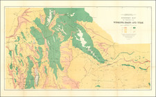
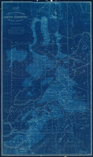
Highly detailed map of a portion of Idaho and Eastern Washington, showing the construction of the Mullan Road between 1859 and 1862.
Carl Wheat describes Mullan's work as follows:
John Mullan's labors in the Pacific Northwest comprise a significant chapter in the history of that region, meriting much more attention than they have had, and more than we shall be able to give them... The Mullan Trail was unquestionably the most famous road ever constructed in the high Northwest.
The map shows the road between Fort Taylor at the confluence of the Palouse River and Snake River and the Coeur D'Alene Mission, with two routes identified, the "Military Road 59 & 60" and "Captain Mullan's Military Wagon Road of 61 & 62." The map also details a number of the the expedition campsites and multiple battle sites, including:
- Col. Steptoe's battleground May 17th 1858 Battle of Four Lakes Sep 1st 1858
- Battle of Spokane Plains September 5th 1858,
The present map focuses on the survey and creation of the so-called Mullan Road. John Mullan had previously been placed in charge of selecting a wagon route between Fort Benton and Fort Walla Walla in Washington. He returned to the Washington Territory, and from 1858 to 1862 was engaged as chief of construction in building the Mullan Road across the Rockies.
During this same period, Lt. Mullan fought in the Wright Campaign in September 1858 where he was in charge of the Nez Percé scouts.
John Mullan
John Mullan, Jr. (1830-1909) was an American soldier, explorer, civil servant, and road builder. After graduating from the United States Military Academy in 1852, he joined the Northern Pacific Railroad Survey, led by Isaac Stevens. He extensively explored western Montana and portions of southeastern Idaho, discovered Mullan Pass, and led the construction crew which built the Mullan Road in Montana, Idaho, and Washington state between the spring of 1859 and summer 1860.
![Map of the United States And Territories, Together with Canada &c. [Shows Massive Idaho Territory]](https://storage.googleapis.com/raremaps/img/small/100353.jpg)