|
||

|

|
|

|
The definitive Dutch Golden Age atlas of the Americas.
23 double-page engraved maps, vibrantly hand-colored in full and highlighted in gold.
[2], 19, [2], 21-287, [3] pages of Latin text.
Folio, contemporary full vellum, blindstamped and gilt in the Dutch scheme.
Johannes Blaeu's atlas of the Americas is an attractive and important atlas that deftly blended contemporary geographical knowledge with rich decorative imagery. Blaeu's maps set the standard for the quality of the engraving, paper, and color, as well as a fine depiction of contemporary geographical knowledge. While other atlases covered the Americas in comparable detail, none of them held the same august position achieved by Johannes Blaeu's great work.
The Atlas Arms Race of the 17th Century
No discussion of the Atlas maior or its constituent books would be complete without an appraisal of the rivalry between the firms Jansson and Blaeu.
For decades in the middle of the 17th century, the firms Jansson and Blaeu were engaged in ongoing one-upmanship in the atlas market. If Blaeu published a two-volume atlas with 210 maps, Jansson would closely follow with a three-volume 300-map atlas. This process continued on and on.
After the death of Willem Jansz. Blaeu in 1638, the competition picked up still more; both firms issued a new multi-volume atlas: the Atlas novus. At that point, they did not hesitate to issue more and more volumes and to copy one another's maps. By the end of 1658, Bleau had published an Atlas novus with six volumes and 400 maps, while Jansson had published a six-volume Atlas novus with 450 maps.
A new weapon was needed in the atlas wars, and so Jansson issued his 10 to 11 volume German-language Novus Atlas absolutissimus. The set had a huge complement of maps, between 500 and 550, and when combined with Cellarius's celestial atlas, and Jansson's eight-volume town book, his firm was the first to realize a complete description of the countries, towns, oceans, and heavens, following the 16th century Mercator concept.
Johannes Blaeu was not to be outdone, however. In 1662, Blaeu issued his Atlas maior (Major Atlas) in eleven volumes, with approximately 600 maps. He would follow it with French and Dutch editions and attempt to complete a Spanish edition. The Americas volume was the last volume included in the Atlas maior. The set was the largest, most impressive, and most expensive publication of the 17th century, and it stands as the pinnacle of printed atlases.
In 1672, a fire broke out in the Blaeu firm workshop, decimating the stock and the business, and bringing an end to the in-progress publication of the Spanish language edition of the Atlas Maior at 10 volumes -- it was originally supposed to run to 12. Johannes Blaeu died the following year, and the family business declined thereafter.
Maps Included in the Atlas:
-
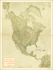
Americae Nova Tabula. ( www.raremaps.com/maps/large/47551a.jpg )
-
Extrema Americae Versus Boream, ubi Terra Nova Nova Francia, Adjacentiag.
-
Nova Belgica et Anglia Nova. ( www.raremaps.com/maps/large/47551b.jpg )
-
Nova Virginiae Tabula.
-
Virginiae partis australis, et Floridae partis orientalis, interjacentiumq regionum Nova Descriptio. ( www.raremaps.com/maps/large/47551c.jpg )
-
Nova Hispania et Nova Galicia. ( www.raremaps.com/maps/large/47551d.jpg )
-
Yucatan Conventus Iuridici Hispaniae Novae Pars Occidentalis, et Guatimala Conventus Iuridicus. ( www.raremaps.com/maps/large/47551e.jpg )
-
Insulae Americanae In Oceano Septentrionali, cum Terris adiacentibus. ( www.raremaps.com/maps/large/47551f.jpg )
-
Canibales Insulae.
-
Mappa Aestivarum Insularum, alias Barmudas dictarum, ad Ostia Mexicani aestuarij jacentium in latitudine Graduum 32 Mintorum 25. Ab Anglia, Londino scilicet versus Libonotum 3300 Miliaribus Anglicans, et a Roanoack ( qui locus est in Virginia ) versus Euronotum 500 Mill. accurate descripta.
-
Terra Firma et Novum Regnum Granatense et Popayan ( www.raremaps.com/maps/large/47551g.jpg )
-
Chili
-
Tabula Magellanica, qua Tierrae del fuego, cum celeberrimis fretis a F. Magellano et I. Le Maire detestis novissima et accuratissima descriptio exhibetur.
-
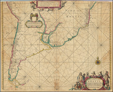
Paraquaria Vulgo Paraguay. Cum adjacentibus.
-
Nova et Accurata Brasiliae totius Tabula, Auctore Ioanne Blaeu I.F.
-
Sinus Omnium Sanctoru.
-
Praefectura De Ciriii, vel Seregippe Delrey cum Itapuama.
-
Praefecturae Paranambucae Pars Borealis, una cum Praefectura de Itamaraca.
-
Praefecturae Paranambucae Pars Meridionalis.
-
Praefecturae de Paraiba, et Rio Grande.
-
Guiana sive Amazonum Regio ( www.raremaps.com/maps/large/47551i.jpg )
-
Venezuela, cum parte Australi Novae Andalusiae.
Provenance:
Ink library stamp on recto of title page and two on verso.
Joan, or Johannes, Blaeu (1596-1673) was the son of Willem Janszoon Blaeu. He inherited his father’s meticulous and striking mapmaking style and continued the Blaeu workshop until it burned in 1672. Initially, Joan trained as a lawyer, but he decided to join his father’s business rather than practice.
After his father’s death in 1638, Joan and his brother, Cornelis, took over their father’s shop and Joan took on his work as hydrographer to the Dutch East India Company. Joan brought out many important works, including Nova et Accuratissima Terrarum Orbis Tabula, a world map to commemorate the Peace of Westphalia which brought news of Abel Tasman’s voyages in the Pacific to the attention of Europe. This map was used as a template for the world map set in the floor of the Amsterdam Town Hall, the Groote Burger-Zaal, in 1655.
Joan also modified and greatly expanded his father’s Atlas novus, first published in 1635. All the while, Joan was honing his own atlas. He published the Atlas maior between 1662 and 1672. It is one of the most sought-after atlases by collectors and institutions today due to the attention to the detail, quality, and beauty of the maps. He is also known for his town plans and wall maps of the continents. Joan’s productivity slammed to a halt in 1672, when a fire completely destroyed his workshop and stock. Joan died a year later and is buried in the Westerkerk in Amsterdam.
![[Central America]](https://storage.googleapis.com/raremaps/img/small/77960.jpg)