![[English Edition!] Nova Totius Terrarum Orbis Geographica Ac Hydrographica Tabula Auct. Henr: Hondio. . . . 1630 By Henricus Hondius](https://storage.googleapis.com/raremaps/img/small/78002.jpg)


|
||

|

|
|

|
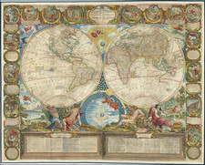
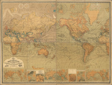
Rare Final State of oe Of The Most Famous World Maps of the 17th Century with Portraits of Gerard Mercator and Jodocus Hondius
Spectacular old color example of Hondius' decorative world map, first issued in the 1630 edition of the Mercator-Hondius Atlas, in response to competition from Willem Blaeu. This is the final state of the map, with the date 1666 added and significant cartographic updates as noted below.
The present example is the extremely rare final state of the map, which has been revised to show the Dutch discoveries in Australia (Hollandia Nova), including Abel Tasman's discovery of Van Diemen's Land (Tasmania) and the coastline of New Zealand, as discovered by Tasman. Most of the Coastline of Terra Australis Incognita has been removed. 't Land van Eso has also been added to the north of Japan.
In the western hemisphere, the West Coast of North America has been revised. The Straet de Vries in sknow shown, as is Compagnies Land, and a revised westernmost coastline, with new place names and the removal of Nova Albion, Cape Mendocino, Cape Nevado, etc. In the South Pacific, to the north of New Zealand, the Eyl. Rotterdam and Eyl Amsterdam appear and a bit further west, the I de S. Pedro.
As with prior editions, California is shown as an island and Korea is now called an Isthmus, no longer being represented as an Island, with a large and impressive early representation of the Philippines below.
In South America, the Straits of Le Maire now appear, although Hondius still hints at a narrow channel between Terra Australis and Tierra del Fuego.
In the Sea of Cortez, a curious double set of rivers empties out of the Southwest, with an unnamed Rio Grande draining incorrectly into the Sea of Cortez, rather than the Gulf of Mexico.
A primitive conception of the Mississippi River is present, but no sign of the Great Lakes. Virginia is prominently named and to the north, the newly discovered regions reached by Henry Hudson are identified with his name.
The map includes portraits of Ptolemy, Mercator, Hondius and Julius Caesar, in the richly ornate decorative borders. The map includes an early appearance of Australia's Northern Coastline. One of the most beautiful world maps of the period.
The present edition is quite rare, this being the first example we have ever seen.
Henricus Hondius (1597-1651) was a Dutch engraver and mapmaker, a member of a prominent cartographic family. His father, Jodocus Hondius, was also an engraver and geographer. While working with his father, Henricus was instrumental in the expansion and republishing of Mercator’s atlas, first published in 1595 and republished by Hondius in 1606.
Upon his father’s death in 1612, Henricus and his brother, Jodocus the Younger, took over the business. He set up his own shop in 1621, where he continued to release new editions of the Mercator atlas. Later, he partnered with his brother-in-law, Jan Janssonius, in continuing to expand and publish Mercator’s atlas, which would become known as the Mercator-Hondius-Janssonius atlas. Born and based in Amsterdam, he died there in 1651.
Jan Janssonius (also known as Johann or Jan Jansson or Janszoon) (1588-1664) was a renowned geographer and publisher of the seventeenth century, when the Dutch dominated map publishing in Europe. Born in Arnhem, Jan was first exposed to the trade via his father, who was also a bookseller and publisher. In 1612, Jan married the daughter of Jodocus Hondius, who was also a prominent mapmaker and seller. Jonssonius’ first maps date from 1616.
In the 1630s, Janssonius worked with his brother-in-law, Henricus Hondius. Their most successful venture was to reissue the Mercator-Hondius atlas. Jodocus Hondius had acquired the plates to the Mercator atlas, first published in 1595, and added 36 additional maps. After Hondius died in 1612, Henricus took over publication; Janssonius joined the venture in 1633. Eventually, the atlas was renamed the Atlas Novus and then the Atlas Major, by which time it had expanded to eleven volumes. Janssonius is also well known for his volume of English county maps, published in 1646.
Janssonius died in Amsterdam in 1664. His son-in-law, Johannes van Waesbergen, took over his business. Eventually, many of Janssonius’ plates were sold to Gerard Valck and Pieter Schenk, who added their names and continued to reissue the maps.
![[Early Photographic Facsimile of the 1529 Ribero World Map]](https://storage.googleapis.com/raremaps/img/small/67279.jpg)