|
||

|

|
|

|
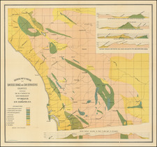
Rare Topograpical Map of Sierra County, Compiled by Charles W. Hendel and lithographed by Britton & Rey in San Francisco.
The map presents and attractive topographical images, focusing on the mountains, mines, towns, roads, and other features.
Of equal interest are the fine vignettes at the sides, including:
- Early Skiing Image
- Placer Mining in Winter and Summer
- Chinese Miners
- Hydraulic Mining
- Interior of a Mine Shaft
CHARLES W. HENDEL was born in Saxony, July 21, 1831 and educated at Dresden, graduating from the Zchocko Technic Institute in 1850. Two years later he came to the United States, living in New Jersey and Connecticut until the spring of 1853, when he came to California. After mining for a time on the American River, Hendel went to St. Louis, in Sierra County, and engaged in mining till 1860, when he was elected County Surveyor of Sierra County, an office he held two terms.
Thereafter, Hendel served as a surveyor. In 1871 he was appointed deputy U.S. surveyor. He moved to La Porte, Plumas County, the same year, and in 1879 was elected County Surveyor. He owned a large interest in the Alturas tailing mine on Slate Creek and nearly all claims on Port Wine ridge, known as the Lucky Gold Hill Mine which covered nearly 800 acres.
OCLC/WorldCat locates only four copies, at U.C. Berkeley, U.C. Davis, and two at Harvard.
![[Imperial & Coachella Valley Advertising Map -- Valerie Jean Date Shop]](https://storage.googleapis.com/raremaps/img/small/69651.jpg)