![Amerique Septentrionale divisee en Ses Principales parties . . . . 1692 [California as an Island] By Alexis-Hubert Jaillot](https://storage.googleapis.com/raremaps/img/small/95812.jpg)


|
||

|

|
|

|
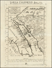
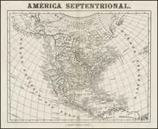
Jaillot’s Impressive Map of North America, with California as an Island
Fine, dark impression of Jaillot's striking, large-format map of North America, showing California as an island.
The map, printed in a wide-format, shows all that was then known of North America on a curved projection. The tip of South America is included, as are the British Isles. In the Pacific, a phantom coastline is labeled as “Terre de Iesso, ou Ieco,” a reference to a series of North Pacific chimeras related to the search for land sighted by Juan de Gama in the sixteenth century.
Details are densely included in Mexico and Central America, as well as the East Coast of North America. Beyond the Appalachian Mountains and outside Nueva España, however, there is much blank space and conjecture. For example, in what is now Texas is Quivira. This is a reference to the Seven Cities of Gold sought by the Spanish explorer Francisco Vasquez de Coronado in 1541. In 1539, Coronado wandered over what today is Arizona and New Mexico, eventually heading to what is now Kansas to find the supposedly rich city of Quivira. Although he never found the cities or the gold, the name stuck on maps of southwest North America, wandering from east to west.
The most striking geographic feature is certainly California depicted as an island. Also of note is the representation of the Great Lakes, which are open at the west end. The far north is riddled with incomplete coastlines, showing the nascent degree of exploration in that area. There is also a suggestive open end to Buttons Bay, a tantalizing possibility of a Northwest Passage.
To the southward, the Mississippi is called the Chucagua and is farther east than previous mappings. There is a massive lake in Florida called Apalache, a mis-mapping of Lake George stemming from the work of De Bry and Le Moyne.
As the title running along the top edge explains, an important part of the map is to denote the political divisions of European imperial possessions. These are marked by dotted lines on the map. An eight-layered scale is in the lower left, with indigenous Americans on either side of the ornate frame. In the upper left is the title cartouche and dedication, another ornate embellishment with indigenous Americans, parrots, and the coat of arms of the Dauphin, the dedicatee. The title cartouche also credits Nicolas Sanson; indeed, the depiction of California is based on the second Sanson or the Luke Foxe model, while the East Coast is derived from his map of 1666.
Due to the rocky relationship between the Jaillot and Sanson firms, there are several closely-related yet separate plates of this map. This is the Covens & Mortier issue of 1692, identifiable by the line of longitude bisecting the first “A” in Apaches Vaqueros.
North Pacific chimeras: Yesso, De Gama, and Compagnie Land
The etymology of the idiom Yesso (Eso, Yeco, Jesso, Yedso) is most likely the Japanese Ezo-chi; a term used for the lands north of the island of Honshu. During the Edō period (1600-1886), it came to represent the ‘foreigners’ on the Kuril and Sakhalin islands. As European traders came into contact with the Japanese in the seventeenth century, the term was transferred onto European maps, where it was often associated with the island of Hokkaido. It varies on maps from a small island to a near-continent sized mass that stretches from Asia to Alaska.
The toponym held interest for Europeans because the island was supposedly tied to mythic riches. Father Francis Xavier (1506-1552), an early Jesuit missionary to Japan and China, related stories that immense silver mines were to be found on a secluded Japanese island; these stories were echoed in Spanish reports. The rumors became so tenacious and tantalizing that Abraham Ortelius included an island of silver north of Japan on his 1589 map of the Pacific.
Yesso is often tied to two other mythical North Pacific lands, Gamaland and Compagnies Land. Juan de Gama, the grandson of Vasco de Gama, was a Portuguese navigator who was accused of illegal trading with the Spanish in the East Indies. Gama fled and sailed from Macau to Japan in the later sixteenth century. He then struck out east, across the Pacific, and supposedly saw lands in the North Pacific. These lands were initially shown as small islands on Portuguese charts, but ballooned into a continent-sized landmass in later representations.
Several voyagers sought out these chimerical islands, including the Dutchmen Matthijs Hendrickszoon Quast in 1639 and Maarten Gerritszoon Vries in 1643. Compagnies Land, often shown along with Staten Land, were islands sighted by Vries on his 1643 voyage. He named the islands for the Dutch States General (Staten Land) and for the Dutch East India Company (VOC) (Compagnies, or Company’s Land). In reality, he had re-discovered two of the Kuril Islands. However, other mapmakers latched onto Compagnies Land in particular, enlarging and merging it with Yesso and/or Gamaland.
In the mid-eighteenth century, Vitus Bering, a Danish explorer in Russian employ, and later James Cook would both check the area and find nothing. La Perouse also sought the huge islands, but found only the Kurils, putting to rest the myth of the continent-sized dream lands.
The popular misconception of California as an island can be found on European maps from the sixteenth through the eighteenth centuries. From its first portrayal on a printed map by Diego Gutiérrez, in 1562, California was shown as part of North America by mapmakers, including Gerardus Mercator and Abraham Ortelius. In the 1620s, however, it began to appear as an island in several sources. While most of these show the equivalent of the modern state of California separated from the continent, others, like a manuscript chart by Joao Teixeira Albernaz I (ca. 1632) now in the collection of the National Library of Brasil shows the entire western half of North Americas as an island.
The myth of California as an island was most likely the result of the travel account of Sebastian Vizcaino, who had been sent north up the shore of California in 1602. A Carmelite friar, Fray Antonio de la Ascensión, accompanied him. Ascension described the land as an island and around 1620 sketched maps to that effect. Normally, this information would have been reviewed and locked in the Spanish repository, the Casa de la Contratación. However, the manuscript maps were intercepted in the Atlantic by the Dutch, who took them to Amsterdam where they began to circulate. Ascensión also published descriptions of the insular geography in Juan Torquemada’s Monarquia Indiana (1613) (with the island details curtailed somewhat) and in his own Relación breve of ca. 1620.
The first known maps to show California as an island were on the title pages of Antonio de Herrera’s Descripción de las Indias Occidentales (1622) and Jacob le Maire's Spieghel Der Australische Navigatie (1622). Two early examples of larger maps are those by Abraham Goos (1624) and another by Henry Briggs, which was included in Samuel Purchas’ Hakluytus Posthumus or Purchas his Pilgrimes (1625). In addition to Briggs and Goos, prominent practitioners like Jan Jansson and Nicolas Sanson adopted the new island and the practice became commonplace. John Speed’s map (1626-7), based on Briggs’ work, is well known for being one of the first to depict an insular California.
The island of California became a fixture on mid- and late-seventeenth century maps. The island suggested possible links to the Northwest Passage, with rivers in the North American interior supposedly connecting to the sea between California and the mainland. Furthermore, Francis Drake had landed in northern California on his circumnavigation (1577-80) and an insular California suggested that Spanish power in the area could be questioned.
Not everyone was convinced, however. Father Eusebio Kino, after extensive travels in what is now California, Arizona, and northern Mexico concluded that the island was actually a peninsula and published a map refuting the claim (Paris, 1705). Another skeptic was Guillaume De L’Isle. In 1700, De L’Isle discussed “whether California is an Island or a part of the continent” with J. D. Cassini; the letter was published in 1715. After reviewing all the literature available to him in Paris, De L’Isle concluded that the evidence supporting an insular California was not trustworthy. He also cited more recent explorations by the Jesuits (including Kino) that disproved the island theory. Later, in his map of 1722 (Carte d’Amerique dressee pour l’usage du Roy), De L’Isle would abandon the island theory entirely.
Despite Kino’s and De L’Isle’s work, California as an island remained common on maps until the mid-eighteenth century. De L’Isle’s son-in-law, Philippe Buache, for example, remained an adherent of the island depiction for some time. Another believer was Herman Moll, who reported that California was unequivocally an island, for he had had sailors in his offices that claimed to have circumnavigated it. In the face of such skepticism, the King of Spain, Ferdinand VII, had to issue a decree in 1747 proclaiming California to be a peninsula connected to North America; the geographic chimera, no matter how appealing, was not to be suffered any longer, although a few final maps were printed with the lingering island.
Alexis-Hubert Jaillot (ca. 1632-1712) was one of the most important French cartographers of the seventeenth century. Jaillot traveled to Paris with his brother, Simon, in 1657, hoping to take advantage of Louis XIV's call to the artists and scientists of France to settle and work in Paris. Originally a sculptor, he married the daughter of Nicholas Berey, Jeanne Berey, in 1664, and went into partnership with Nicholas Sanson's sons. Beginning in 1669, he re-engraved and often enlarged many of Sanson's maps, filling in the gap left by the destruction of the Blaeu's printing establishment in 1672.
![[ Southern California Tourism ] Hunting and Fishing in Southern California on the Santa Fe](https://storage.googleapis.com/raremaps/img/small/101613.jpg)