|
||

|

|
|

|
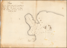
The Battle of Puebla--Cinco de Mayo
Detailed map of the area around the City of Puebla in Mexico, published by Emile Andriveau Goujon in Paris.
The map shows major roads, some buildings, fortifications, and locations of French and Mexican troops during the May 5, 1862, Battle of Puebla.
Includes key showing the various military fortifications, along with the positions of the Mexican and French trooops and a French encampment.
Other keys identify churches and principle buildings, plazas, and mountains.
Battle of Puebla--Cinco de Mayo
The Battle of Puebla occured during the French intervention in Mexico. The battle ended in a victory for the Mexican Army over the occupying French forces. The French eventually overran the Mexicans in subsequent battles, but the Mexican victory at Puebla against a much better equipped and larger French army provided a significant morale boost to the Mexican army and also helped slow the French army's advance towards Mexico City.
The Mexican victory is celebrated yearly on the fifth of May. Its celebration is regional in Mexico, primarily in the state of Puebla, where the holiday is celebrated as El Día de la Batalla de Puebla.
There is some limited recognition of the holiday in other parts of the country. Curiously, Cinco de Mayo has become very popular in the United States.
Rarity
The plan is apparently very rare. We note only the example in the collection of the University of Texas at Arlington.
![(Mexican Antiquities - Photography) [Great Palace, Mitla, Oaxaca, Mexico; Grand Palais, à Mitla] [Plate 10 from:] Cités et Ruines Américaines](https://storage.googleapis.com/raremaps/img/small/93939.jpg)
![(Mexican Antiquities - Photography) [South Side of Nun's Palace, Uxmal; Palais Des Nonnes, à Uxmal; cote sud] [Plate 42 from:] Cités et Ruines Américaines](https://storage.googleapis.com/raremaps/img/small/93938.jpg)