|
||

|

|
|

|
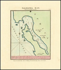
The First Modern Map of Table Bay, South Africa
Cornerstone map of Table Bay and Cape Town, South Africa, from the extremely rare and important "Secret Atlas" of the Dutch East India Company (VOC).
While it has been suggested that the chart may have been rendered as early as 1728, it was first published decades later by Johannes (II) Van Keulen, in the VOC Secret Atlas in 1753. There exists several VOC manuscript charts from 1722 which provide cover a similar region, although this printed chart is more cartographically detailed and advanced.
The chart provides an unparalleled view of Table Bay and the surrounding area during the 1720s.
The map serves as both a practical sea chart, allowing for the maritime navigation of Table Bay, and a plan of the terrestrial layout of the small town below table mountain (now Cape Town). The map shows the coastal fortifications and the "Company's Garden" (of the VOC), which still exists. Interestingly the map shows a Dutch settlement on Robben Island, which the VOC then used for a prison and which would attain greater notoriety when Nelson Mandela was imprisoned there for 18 years.
The map includes a plethora of detail about the colony that was previously unrecorded in charts of the area. For instance:
-The infamous public Gallows near the Castle (now lower Buitenkant Street) and the Wheel Gallows (both labelled as 'Justitie').
-The Cape windmill (Caapsche Windmole) on the banks of the Liesbeek River, in the area of the first expansion of the nascent colony towards the east. This, of course, shows the beginning of the grain industry in the area. The windmill was fully demolished in the 20th century.
-Indicates the three main roads (to the north, east, and south). The roads still follow mostly the same route for miles.
-The watermill (Watermole). This indicates the beginning of the beer industry in the Cape; the same springs still supply the local industry today.
-The "Lion's Rump" and "Lion's Head".
-The anchor-ground.
Van Keulen's chart was later copied by Sayer & Bennett around 1778 (and thereafter amended by Laurie & Whittle in 1794), under the title: A Plan of Table Bay with the Road of the Cape of Good Hope, from the Dutch Survey Published by Joannes Van Keulen. This signaled an increasing British interest in the Cape of Good Hope. In 1795, the British invaded and occupied the Cape Colony, in response to the French takeover of the United Netherlands.
The VOC Secret Atlas
The so-called "Secret Atlas" of the Dutch East India Company was, in fact, Part VI of the Zee-Fakkel, published by Johannes (II) Van Keulen, from 1753. For the first 150 years of the Company's history, the VOC had resisted producing printed sea charts of the area east of South Africa, which the VOC saw as their proprietary region. By keeping these charts secret, the best available navigational information and coastal details would remain proprietary. To this end, manuscript charts were produced with proprietary information by the likes of Isaak de Graaf.
The Secret Atlas (Volume VI of the Zee-Fakkel), like the VOC manuscript maps before it, was never offered for sale to the public and was only issued to VOC ships, with explicit instructions that the charts must be returned at the completion of each voyage.
It is interesting to note that Sayer & Bennett published a nearly identical version of the map and credited Van Keulen with its production. This shows that decades after it had first been issued, the Van Keulen name and the VOC knowledge contained on the chart still carried real weight among the British public. The knowledge was still worth keeping secret -- and worth stealing!
Rarity
The map is extremely rare on the market. We locate only a single example offered for sale by a dealer in the past 30 years and no other examples in published auction records.
We extend special thanks to Roger Stewart for his assistance in cataloging this map.
The Van Keulens were a family of chartmakers and publishers. The firm, In de Gekroonde Lootsman (In the Crowned Pilot), was founded in 1678 by Johannes van Keulen (1654-1715). Van Keulen originally registered his business as a vendor of books and instruments (specifically cross-staffs). In 1680, however, he gained a privilege from the States of Holland and West Friesland for the publication of pilot guides and sea atlases.
In that year, van Keulen released his Zee-Atlas (Sea Atlas), which secured him a name in the competitive maritime publishing market. In 1681, he published the first volume of Nieuwe Lichtende Zee-Fakkel (New Shining Sea Torch). This would be the first of an eventual five volumes originally published between 1680 and 1684. A sixth volume was added in 1753. The Zee-Fakel won van Keulen lasting fame. The atlas had charts compiled by Claes Jansz Vooght and artwork from Jan Luyken. It proved immensely popular and was reprinted until 1783. There were translations in French, English, Spanish, and Italian.
The late-seventeenth century was an auspicious time to enter the maritime chart business. Previous industry leaders had either closed shop, died, or retired, leaving space for a new competitor. Van Keulen proceeded to buy up the stock and privileges of several maritime publishing firms; the most notable was the stock of Hendrik Doncker, acquired in 1693.
Johannes’ son, Gerard (1678-1726) took over the business upon his father’s death. Gerard was a skilled engraver and mathematician. His talents were noticed, as in 1706 he was named as Hydrographer to the Dutch East India Company (VOC).
In turn, Gerard’s son Johannes II (1704-1770) came to run the shop. He was also tied to the VOC, and his role as their chartmaker allowed his charts to be considered as quasi-official government documents. It is with access to formerly clandestine VOC geographic knowledge that Johannes the Younger was able to add a sixth volume to the Zee-Fakkel, which covered the East Indies. Johannes also continued to sell instruments, including the recently-invented Hadley’s Quadrant from 1744.
When Johannes II died in 1770, his widow ran the business in his stead, aided by her two sons, Cornelis Buys (1736-1778) and Gerard Hulst (1733-1801). Now a century old, the family business had extended to include an anchor factory. After Cornelis died in 1778, Gerard took on the management of the firm alone. He oversaw the introduction of sextants to their inventory and published the Dutch Nautical Almanac beginning in 1788. Annual editions appeared until 1885. Gerard also served as an original member of the Dutch Commission for Longitude at Sea from 1787.
Gerard’s widow ran the business for nine years after his death, when their son, Johannes Hulst, started to lead the firm in 1810. After his death in 1844, the firm passed out of family hands and into the control of Jacob Swert, a skilled cartographer who had worked for the business for two decades. He passed the work to his son, another Jacob, in 1866. By the mid-nineteenth century, the conversion from sail to steam had diminished the size of the market for charts. Fewer sailors needed fewer maps, charts, and instruments. In 1885, after 207 years in business, In de Gekroonde Lootsman closed its doors and auctioned its stock.
![[ Cape of Good Hope / Cape Town, South Africa ] The Dutch Colony of the Cape of Good Hope by L.S. De La Rochette MDCC XCV](https://storage.googleapis.com/raremaps/img/small/96510.jpg)