


|
||

|

|
|

|
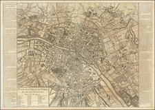
Fine example of Jansson' rare town plan of 16th Century Paris, based on Sebastian Munster's map of 1569.
Paris began as a small settlement on an island in the Seine, named Lutetia by the Gallii Parisii. This island, seen at the center of the map, controlled the trade in the region both along the river and via the north-south roads crossing the island. Paris grew through successive periods, with walls, citadels, and forts added through a series of expansions. The Bastille is shown at the upper center of the engraving and the Cathedral of Notre Dame is on the eastern end of on the island. The plan is oriented with east at the top.
Originally issued by Braun & Hogenberg in 1572 in their landmark Civitates Orbis Terrarum, the plates were later acquired by Jansson, who issued his own town book in 1657, with the plates reworked to remove the costumed figures, which were no longer of contemporary interest. While the original addition is readily obtainable on the market, the Jansson edition is comparatively rare.
This view come from Theatrum Urbium Celebriorum, Jansson's version of Braun & Hogenberg's Civitatus Orbis Terrarum.An eight-volume example of Jansson's town books sold for more than $300,000 at auction 10 years ago.
Jan Janssonius (also known as Johann or Jan Jansson or Janszoon) (1588-1664) was a renowned geographer and publisher of the seventeenth century, when the Dutch dominated map publishing in Europe. Born in Arnhem, Jan was first exposed to the trade via his father, who was also a bookseller and publisher. In 1612, Jan married the daughter of Jodocus Hondius, who was also a prominent mapmaker and seller. Jonssonius’ first maps date from 1616.
In the 1630s, Janssonius worked with his brother-in-law, Henricus Hondius. Their most successful venture was to reissue the Mercator-Hondius atlas. Jodocus Hondius had acquired the plates to the Mercator atlas, first published in 1595, and added 36 additional maps. After Hondius died in 1612, Henricus took over publication; Janssonius joined the venture in 1633. Eventually, the atlas was renamed the Atlas Novus and then the Atlas Major, by which time it had expanded to eleven volumes. Janssonius is also well known for his volume of English county maps, published in 1646.
Janssonius died in Amsterdam in 1664. His son-in-law, Johannes van Waesbergen, took over his business. Eventually, many of Janssonius’ plates were sold to Gerard Valck and Pieter Schenk, who added their names and continued to reissue the maps.
![[Paris] Lutetia vulgari Nomine Paris, Urbs Galliae Maxima . . .](https://storage.googleapis.com/raremaps/img/small/96922.jpg)
![(Paris Region) Agri Parisiensi Tabula particularis… Particulir Karte des Landes und der Schön Weltberühmte Gegend um Paris, so da ist der größte Teil des Gouvernement der Insel von Frankreich, accurat verzeichnet von F. Vivier und verlegt durch J.B. Homann. [Particular Map of the Lands and the Beautiful World-Renowned Region around Paris, which is the Greater Part of the Government of the Isle of France, accurately depicted by F. Vivier and published by J.B. Homann.]](https://storage.googleapis.com/raremaps/img/small/93947.jpg)