|
||

|

|
|

|
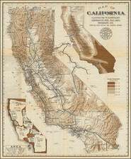
One of the earliest obtainable Automobile Road Maps of Southern California
Rare early Automobile Club map of Southern California, drawn by Elmer J. Brown.
The map provides an interesting topographical depiction of the Los Angeles Basin, extending to Saugus, the Mojave Desert, Cabazon, Idylwild and Temecula. The map is filled with long since forgotten towns, along with roads, railroads, light rail lines, etc.
Elmer J. Brown would go on to draw a number of other maps for the Automobile Club, although this seems to be one of his earliest works.
The geographical concept of Southern California was still quite new. The first maps to focus on Southern California as its own geographical region were published in the mid-1880s. This map draws on the concept of the Los Angeles Basin, extending to Orange County, the "Inland Empire", San Bernardino Mountains and high desert. The modern conception of Southern California includes San Diego and Imperial Counties, which are geographically separated from the rest by the Santa Ana Mountain Range, which is depicted on the present map.