


|
||

|

|
|

|
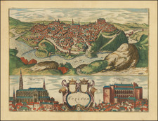
Beautiful example of Braun & Hogenberg's view of Antiquera, from Braun & Hogenberg's Civitatus Orbis Terrarum, the most important book of town plans and views published in the 16th Century.
A fine view of Antequera, with the Sierra de los Torcales in the background. In the foreground the depiction of two peasants with a huge earthenware jug symbolizes the flourishing of agriculture, crafts and trade. In AD 711, Antequera was conquered by the Moors and renamed Medina Antaquira. In the 13th century they built an extensive defense system in the town, in order to be able to resist the attacks of the Christian kings during the Reconquista. Among other things, the castle of Alcazaba was built on a hill overlooking the city. Not until 1410 did an army, under the leadership of Ferdinand I of Aragon, succeed in capturing the town. After this, due to its central position in Andalusia, Antequera became an important commercial centre, in which agriculture and crafts flourished.
Translation of Title Cartouche:
Antequera, Spanish town in the Kingdom of Granada, once royal city of the Moors; noteworthy because of its very pleasant position, its abundance of salt, its stone quarries and potteries.
Translation of text on verso:
Antequera is a well-known and splendid city in the Kingdom of Granada. [...] On the mountain it has a magnificent and well-fortified castle, called the Alcazaba, in which the kings of Granada took up their quarters while the Moors were still in control of the country. [...] Many nobles have their comfortable apartments close to the castle, while the surrounding countryside is inhabited by peasants. These are very wealthy, partly due to the fertility of the soil, and partly because of the salt that they extract and collect. For there are many salt springs in the surrounding mountains.
Georg Braun (1541-1622) was born and died in Cologne. His primary vocation was as Catholic cleric; he spent thirty-seven years as canon and dean at the church St. Maria ad Gradus, in Cologne. Braun was the chief editor of the Civitates orbis terrarum, the greatest book of town views ever published. His job entailed hiring artists, acquiring source material for the maps and views, and writing the text. In this role, he was assisted by Abraham Ortelius. Braun lived into his 80s, and he was the only member of the original team to witness the publication of the sixth volume in 1617.
Frans Hogenberg (ca. 1540-ca. 1590) was a Flemish and German engraver and mapmaker who also painted. He was born in Mechelen, south of Antwerp, the son of wood engraver and etcher Nicolas Hogenberg. Together with his father, brother (Remigius), uncle, and cousins, Frans was one member of a prominent artistic family in the Netherlands.
During the 1550s, Frans worked in Antwerp with the famous mapmaker Abraham Ortelius. There, he engraved the maps for Ortelius’ groundbreaking first atlas, published in Antwerp in 1570, along with Johannes van Deotecum and Ambrosius and Ferdinand Arsenius. It is suspected he engraved the title page as well. Later, Ortelius supported Hogenberg with information for a different project, the Civitates orbis terrarium (edited by Georg Braun, engraved by Hogenberg, published in six volumes, Cologne, 1572-1617). Hogenberg engraved the majority of the work’s 546 prospects and views.
It is possible that Frans spent some time in England while fleeing from religious persecution, but he was living and working in Cologne by 1580. That is the city where he died around 1590. In addition to his maps, he is known for his historical allegories and portraits. His brother, Remigius, also went on to some fame as an engraver, and he died around the same time as his brother.
![[ Basque Harbors ] Kaarte over Pasages Havn / Kaart over Byen St. Sebastian og dens Havn / Kaart over Sudlobet til Bilbao / Havenen ved Santoña](https://storage.googleapis.com/raremaps/img/small/39054se.jpg)