


|
||

|

|
|

|
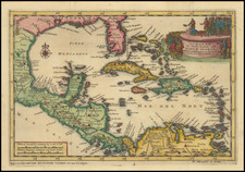
Rare first state of Finley's map of Florida, which first appaered in Finley's New General Atlas in 1831.
The map is one of the earliest maps of Florida to appear in a commercial atlas.
The map is a significant departure from Finley's earlier map of Florida, which appeared in pocket map format in 1826 and in his New American Atlas. In place of the massive Mosquito County shown on the 1826 map, there is a large area (green) labeled Seminoles and Indian Reserve. The remainder of the Florida peninsula is dominated by Alchua County (extending from Charlotte Harbor to the Georgia State Line and Roe County. There are a few other county updates along the Gulf Coast.
The 1831 map is also significantly more detailed than Finley's earlier map. The mythical river near the East Coast of Florida is gone, replaced by hills and a number of early roads. Many more towns and other features are noted. Large insets of Tallahasee and Pensacola.
Late editions of the Finley Atlas are much rarer than the editions issued in 1824 and 1826. This is the second example of this map we have ever seen on the market and there are no reported examples of this map appearing in dealer price guides or auctions in the past 25 years.
Anthony Finley (1784-1836) was an American map publisher. Little is known about his life. He is presumed to have been born in Philadelphia, where he also died. A publisher, Finley was also involved in several Philadelphia civic and professional societies such as the Philadelphia Apprentices’ Library. He may have been in business as early as 1809 and his first publication dates from ca. 1811.
His first maps also date from this year, with two maps in Daniel Edward Clarke’s Travels in Various Countries of Europe, Asia, and Africa. The first atlas published by Finley appeared in 1818, the Atlas classica, or, Select maps of ancient geography, both sacred and profane, for the use of colleges and schools in the United States. He is best known for his A New General Atlas Comprising a Complete Set of Maps (1824), which was a bestseller. There were two editions in 1824, with annual editions until 1834.
Finley was part of the first generation of American publishers who produced high quality, precise maps on American soil. He was in competition with other Philadelphia publishers, for example Henry S. Tanner. Finley’s A New American Atlas Designed Principally to Illustrate the Geography of the United States of America (1826) closely mirrors Tanner’s A New American Atlas Containing Maps of the Several States of the North American Union, with similar groupings of maps; the main difference is the smaller scale of Finley’s maps. Finley printed two editions of this atlas.
![[ Death of a Florida Indian Chief ] Ceremoniae in Regis & Sacerdotum funere observatae. XL.](https://storage.googleapis.com/raremaps/img/small/97768.jpg)
![(Tallahassee, Florida / Signed by John Quincy Adams) [Certification of full payment by John Boyd for 79 acres of land in Tallahassee, acquired from the General Land Office]](https://storage.googleapis.com/raremaps/img/small/86625.jpg)

![(18th-Century Southern Borderlands) [Collection of manuscript letters to Secretary of War James McHenry from confidential U.S. agent John McKee, relating to southern borderlands, Native Americans and Panton, Leslie & Co.; a letter from John McKee written from Mobile, Alabama, to William Blount of Blount's Conspiracy fame; a letter from William Panton concerning John McKee; and letters from Felix D. St. Hilaire, concerning General Victor Collot]](https://storage.googleapis.com/raremaps/img/small/90005.jpg)