|
||

|

|
|

|
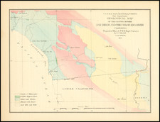
George Davidson's Copy of the 1872 California Boundary Survey -- Photographed by Muybridge and Houseworth
Extremely rare example of this remarkable series of photographs by Edward Muybridge and Thomas Houseworth, showing the original hand drawn survey work of Allexey W. Von Schmidt for his 1872 survey of the California's Eastern Boundary.
Both with ink stamp of George Davidson, U.S. Coast Survey; the first dated Feb. 21, 1873; the second, March 4, 1874. Presumably there was a third sheet which extends down to the 35th parallel, although as noted below, this map seems to survive in only a single complete example at the Bancroft Library.
Surveying California's Eastern Boundary
When California attained statehood in 1850, it adopted 120 degrees west longitude as its eastern border. Between 1855 and 1900 there were six surveys to locate 120 degrees, with each locating 120 degrees of longitude differently.
In the 1860s and 1870s, disputes raged between California and the newly formed state of Nevada as to the exact location of the boundary. Despite legislation that defined where the boundary must be, the two states were in continous conflict. Nevada felt the boundary should be the crest of the Sierra, while California thought it should be further east. For instance, Susanville in the northeast was claimed by both California and Nevada. At times, the dispute led to violent conflict.
Survey after survey was taken to firmly establish the line. The lines never agreed and they were seldom straight. Some survey lines varied from today's boundary by as much as three miles. The surveys were mostly performed using 19th century techniques usually referred to as "dead reckoning." For example, signal fires might be set on one mountain peak, while another blaze, supposedly along the same line, would be set on a nearby high point.
The 1872 Von Schmidt Survey
In 1872, an effort was made to resolve the differences and finally mark the actual boundary between the two states. In that year, San Francisco civil engineer Allexey W. Von Schmidt was retained to conduct one ultimate, definitive survey. Von Schmidt was a well-known figure who had a prosperous dredging business and done some preparatory work for the construction of the San Francisco Cable Car system. Von Schmidt was provided with a $40,750.32 government contract for the boundary survey. Von Schmidt also arranged to erect cast iron and stone markers along the line, hopefully one mile apart. The markers were five foot tall obelisks engraved with the date of the survey and other useful information. Throughout 1872, Von Schmidt and his surveyors marked the northern boundary from Oregon, and, in 1873, ran the line southeast from Lake Tahoe.
Upon reaching Arizona and the Colorado River, Allexey von Schmidt found that his new boundary line and marker was off by several miles. This was not an unusual occurrence for 19th century surveys and the practice of retracing and correcting the line was standard operating procedure. However, Von Schmidt had spent all of the contract funds. He resolved to start his corrections and petition the government for more money. He had completed only about a third of his revisions on the line north to Lake Tahoe, when von Schmidt learned that his request for more funding was denied. He quit at that point and announced that the survey was completed. The end result was a "straight line boundary" that had a pronounced kink in the middle. His new boundary and its markers would remain for the next twenty years.
When, from 1893 to 1899, the United States Coast and Geodetic Survey resurveyed the area, Von Schmidt's kink was found. It was also discovered that quite a few of the cast iron and stone markers were in the wrong spots as well. The state boundary was corrected, and serves as the present borderline.
Rarity:
The present example is the Davidson-Heckrotte copy, sold by Pacific Book Auctions in 2016. The PBA catalog entry noted 4 examples in OCLC, but this seems to be an error. Two of the examples noted on OCLC were modern photocopies. The first Bancroft Copy is a negative photocopy, described as 1 map on 5 sheets and noting that " Original has ms. text by Willis Drummond in lower right corner," with no mention of Muybridge or Houseworth. The second Bancroft copy is described as 1 map on 7 sheets and makes reference to Bradley & Rulofson, but no mention of Muybridge or Houseworth. A third entry (no location given), seems to match the present example.
As such, it appears the only surviving example or examples of the map are located at the Bancroft Library, which appears to also include the southern sheet, which is lacking in this set.
![(Southern California) Utazás Kalifornia Déli Részeiben [Travel in Southern California] [with map:] Kalifornia déli részei Legújabb kútfök után szerkesztette es rajzolta. [Southern parts of California Edited and drawn after the latest sources.]](https://storage.googleapis.com/raremaps/img/small/92022.jpg)
![National Map Company's California Showing Counties, Cities, Villages, and Post Offices[,] Steam and Electric Railroads, with Stations and Distances between Stations[,] National Forests, Reservations, Parks, Etc.](https://storage.googleapis.com/raremaps/img/small/92408.jpg)