|
||

|

|
|

|
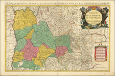
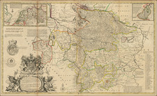
Scarce map of the Austrasie, a Frankish Kingdom, by Melchior Tavernier.
The Kingdom extends from Deventer and Amsterdam in the north, to the Rhine Valley and its sources in the Swiss Alps in the south and east, as well as a large part of northeastern France.
The map is very rare on the market, this being the first example we have ever offered.
Austrasie
Austrasie (Kingdom of the East) is a Frankish kingdom, at the time called Merovingian. The kingdom extemded from the north-east of France, the basins of the Meuse and the Moselle, to the middle and lower basins of the Rhine, reaching to Switzerland. The kingdom of Austrasia is considered the cradle of the Carolingian dynasty.
Melchior Tavernier was a member of a large family involved in the publishing trade in Paris in the early years of the seventeenth century. Early in his career, he apparently collaborated with Henricus Hondius, as at least one of his early maps references Tavernier as the seller of a map engraved in Amsterdam, by Hondius. He is probably best known for his publication of a map of the Post Roads of France, which was copied many times until the end of the century. He also issued an atlas under the same title as J. le Clerc's Theatre Geographique, using many of Le Clerc's maps, but incorporating others from different sources. He published composite atlases and also published works for other cartographers, including N. Sanson, N. Tassin, and P. Bertius. He is not to be confused with his nephew of the same name (1594-1665), who also engraved maps for Nicolas Sanson.
![[Bay of Biscay] Paskaerte Vande Bocht van Vranckrijck Biscajen en Galissen tuscchen Heylant en C. de Finisterre](https://storage.googleapis.com/raremaps/img/small/83967.jpg)