|
||

|

|
|

|
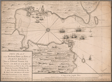
Manuscript Map Possibly Constructed By An Early Surveyor Seeking A Canal Route Across the Isthmus of Panama or Darien
Finely executed map of America, with a large inset of the Isthmus of Panama (and Darien), drawn by P. Hein and apparently sent to his grandmother on December 31, 1871.
The inscription reads "hommage de P. Hein sa grand micre 31 December 1871" (Translation: P. Hein tribute to his grandmother 31 December 1871).
The map is quite fascinating and well executed in its construction, with "guidelines" used for the titles in the Oceans, etc. and a grid constructed for geographical accuracy of the inset map. The oceans are also lightly shaded in grey, with land masses and the polar regions left unshaded.
The maker also uses an elaborate set of color codes, Blue for coastlines, red for national boundaries, brown for major mountain ranges and green for major rivers. The inset of Isthmus of Panama (and Darien) includes a number of place names, including:
- St. Francisco
- Yavisa (Yaviza)
- St. Maria
- St. Cruz
- Chagres
- Pamarama (Panama City)
- Chemie (Punta Chame)
- Pta Begto (?)
- Esrasses (Puerto Escoces)
The map was executed or at minimum dedicated on December 31, 1871. The dedication, construction of the map and use of formal techniques strongly suggests that the map was made at a time when the maker was in Central America. The dating, dedication and technical construction all suggest that his was not a "school girl" project map or created by an amateur.
Between 1850 and 1875, the French were actively undertaking surveys for the prospect of a Canal across the Isthmus of Panama and the Isthmus of Darien. With the completion of the Suez Canal in 1869, the focus on such a Canal was very much in focus at the time this map was constructed.
The town of Yaviza is located at strategic point at the confluence of the Rio Chico and the Rio Chucunaque, approximately at the halfway point between the west coast (panama) and the east coast (Columbia). By 1876, part of the British, under Lucien N. B. Wyse were actively surveying the region in an attempt to find the most practiable route for a canal, but the region had been surveyed earlier by the American Corvette Resaca in 1871.
While we have been unable to determine the identity of P. Hein, it would seem to be almost certain that he was part of the French team surveying the region in the early 1870s.
![A Geographical Chart: or, A Scheme, Comprehending The Most Important Particulars Relative To The Geography of North and South-America. : Designed to be an Auxiliary to the Student. Carefully Compiled from the Best authorities, by Amos Bingham [Copy-Right Secured]](https://storage.googleapis.com/raremaps/img/small/41406.jpg)