|
||

|

|
|

|
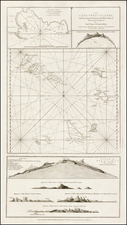
Rare separately issued sea chart of Madgascar, the Mozambique Channel and contiguous regions, published in London by William Herbert.
The map provides an exceptionally detailed treatment of Madgascar and the neighoring islands and coastline.
William Herbert is perhaps best known for his A New Directory for the East-Indies . . . , a set of sailing directions originally published by William Herbert, William Nichelson and Samuel Dunn and later expanded by Gabriel Wright.
Herbert is one of the first mapmakers to attempt to challenge the virtual monopoly on sea charts of Mount & Page. Most of his separately published charts are very rare on the market.
Herbert's life as a mapmaker began when in 1748, he accepted a position as purser's clerk to three ships belonging to the East India Company. After an adventure with some French men-of-war at Tellicherry, he made a long overland journey with a small company of Indians, adopted a form of local dress and let his beard grow. On returning to England he drew plans of settlements, for which the company gave him a grant. These plans were included in a publication issued by Bowles, printseller, near Mercers' Chapel.
In 1758, he published, 'at the Golden Globe, under the Piazzas, London Bridge,' ' A new Directory for the East Indies, with general and particular charts for the navigation of those seas, wherein the French Neptune Oriental has been chiefly considered and examined, with additions, corrections, and explanatory notes,' a quarto volume, with folio charts. Herbert, who calls himself 'hydrographer,' states in the dedication to the East India Company, 'all that has been set forth in the Neptune Oriental has been carefully examined and compared with the particular remarks and journals of ships in your honour's service, as also some country ones, besides many curious charts and plans I have been favoured with, as well as many collected whilst I was in India.' A second and third edition, unaltered, were issued. William Nicholson supplied the practical sea-knowledge. A fourth edition, 'with additions,' was published by Herbert's successor in 1775; a fifth edition, 'enlarged by S. Dunn,' appeared in 1780.
The English mapmaker William Herbert (1718-95) traveled to India in about 1748 as a purser's clerk. Herbert's cartographic publishing started to take form in the late 1740s, when he set up a map and print shop on London Bridge. In 1758, with the encouragement of the East India Company, he introduced a new pilot guide, A New Directory for the East Indies. Herbert gathered superior sources than those used in Mount & Page's The Third Book, consulting such works as Mannevillette's Neptune Oriental, as well as the navigator William Nicholson and the cartographer Samuel Dunn. He often worked with colleagues, including Jefferys, Sayers, Dury, and Andrews, and is recorded as a seller of the famous Anti-Gallican map. In 1776 he retired, having apparently made a fortune. His business was carried on by Henry Gregory Sr.
![(Canary Islands) Caarte Voor een gedeelte der Canarise Eylanden als Canaria, Tenerifa, Forteventura, etc. [Heightened in Gold!]](https://storage.googleapis.com/raremaps/img/small/83729.jpg)
![Aden Arabiae Foelicis Emporium Celeberrimi Nominis, quo ex India, Aethiopia ... [on sheet with] Mombaza [and] Quiloa [and] Cefala](https://storage.googleapis.com/raremaps/img/small/54473mp2.jpg)